In my former blog, I have talked about the severe 1356 earthquake of Basel. Some 6.2 to 6.4 on the Richter scale, as Laubscher, 2006, says. We have seen the presumed destructive impact of the earthquake in the southern Rhine Rift valley, based on historical reports.
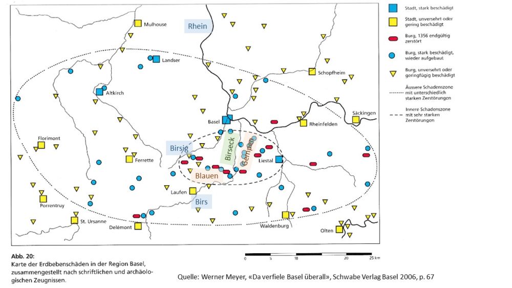
Source: Werner Meyer, “da verfiele Basel überall”, Schwabe Verlag Basel 2006, p. 67
Red denotes castles destroyed and not rebuilt and blue shows castles or cities strongly affected, but rebuilt. Yellow are minor destructions or none, always according to the historical reports analyzed.
To understand more of the geological facts causing the earthquake, let us follow up on these questions:
- How did the Rhine Rift Valley come into existence?
- What is peculiar about the southern end of the rift valley (around Basel)?
- So, what might be the cause for the seismic activity around Basel and for the 1356 earthquake?
A glance at the southern end of the Rhine Rift Valley, around Basel
Basel is located at the southern end of the Rhine Rift valley. To get a feeling for that, let us first have a glance at four photos.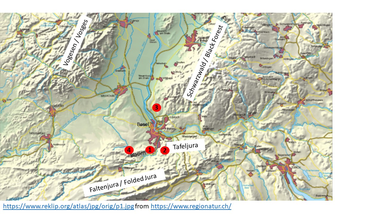
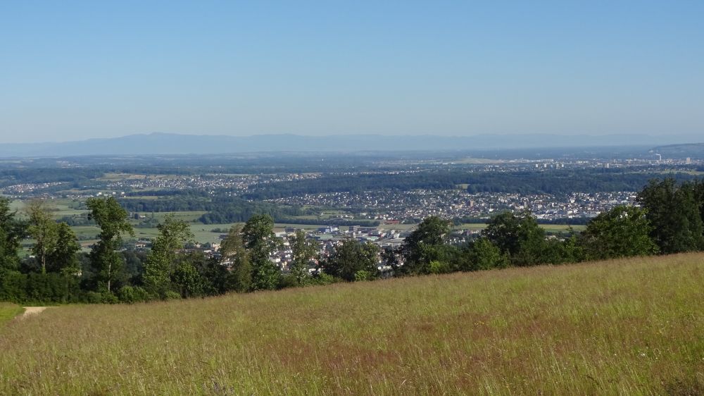
(1) Looking north from the eastern end of the Blauen Chain (Eggfluh), we can see the Birseck with the Gempen Plateau to the right and the Black Forest in the background.

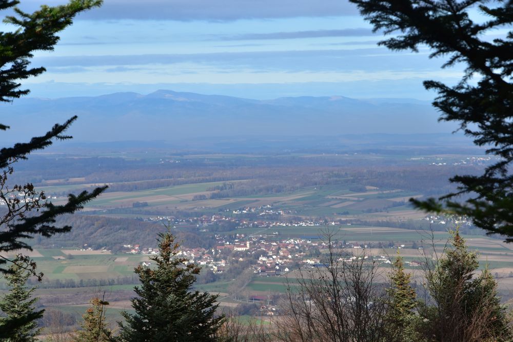
(2) Now we are on the Gempen Plateau in the Tabular Jura (Tafeljura near Hofstetten) and look westwards across the Birseck and the hills of the Sundgau, up to the faint blue line of the Vosges (Vogesen), with the highest peak being the Grand Ballon (France).
(3) Here I am in Germany on the foothills of the Schwarzwald/Black Forest (Markgräflerland) and look south at Basel, with the Gempen Plateau to the left and the folded chains of the Jura in the middle background, including the Blauen to the right.

(4) The fourth photo I took from the Remel at the western end of the Blauen looking northwards across the Sundgau to the Vosges (France). Basel is at about 20km to the right (east).
Yes, Basel is located at the southern end of the Rhine Rift Valley, surrounded by hills and mountains.
How did the Rhine Rift Valley come into existence?
The Rhine Rift Valley emerged long before the unfolding of the Alps and the Jura unfolded. This is a simplified description.
- 150 to 200 million years ago, there was the sea called Tethys that deposited sediments on the ground, on the crystalline basement.
- About 40 million years ago, everything was lifted up which resulted in the basement and the sediments to break apart and slide downwards several thousand meters.
- The Vosges and the Black Forest emerged, and in front of them foothills (Sundgau and Markgräfler Land). The volcano “Kaiserstuhl” erupted some 15-19 Mio years ago.
- The sediments from the sides were eroded filling the trough and uncovering the crystalline basements of the Vosges and the Black Forest. The mountains reach about 1500m, the base of the trough, filled with the sediments, is at around 250m above sea level.
The four stages overlapped in time.
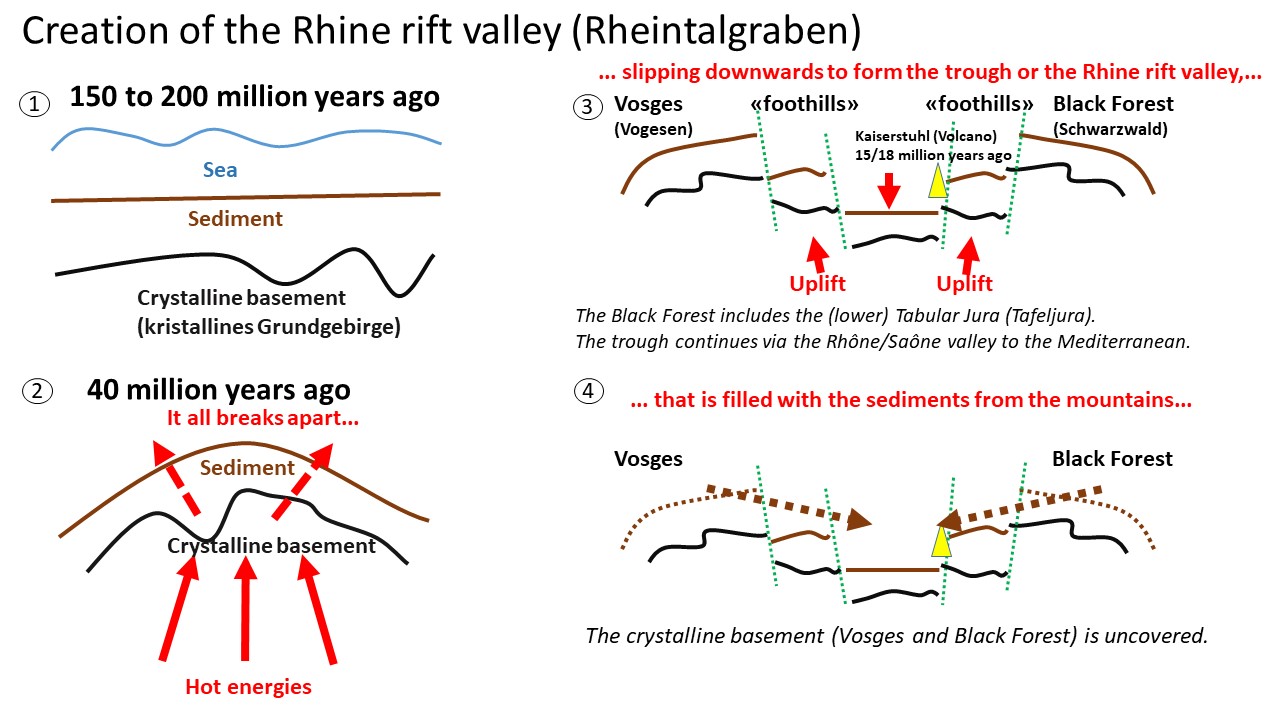
Source: My owns drawing to grasp the verbal descriptions on https://www.regionatur.ch/Orte/Naturraeume-Flusslandschaften/Oberrheinische-Tiefebene (very much simplified)
What is peculiar about the southern end of the rift valley (around Basel)?
The Rhine Rift Valley ends some 20kms south of Basel. The trough formation turned left (westwards) to form the Belfort gap and to continue as the Rhône-Saône Rift Valley up to the Mediterranean.
The Dinkelberg and the Tabular Jura (Tafeljura) belong to the Black Forest, and they are lower. When the trough formed, their sediments bent down forming the so-called “Rheintalflexur” and more such flexures arose such as the Landskronflexur.
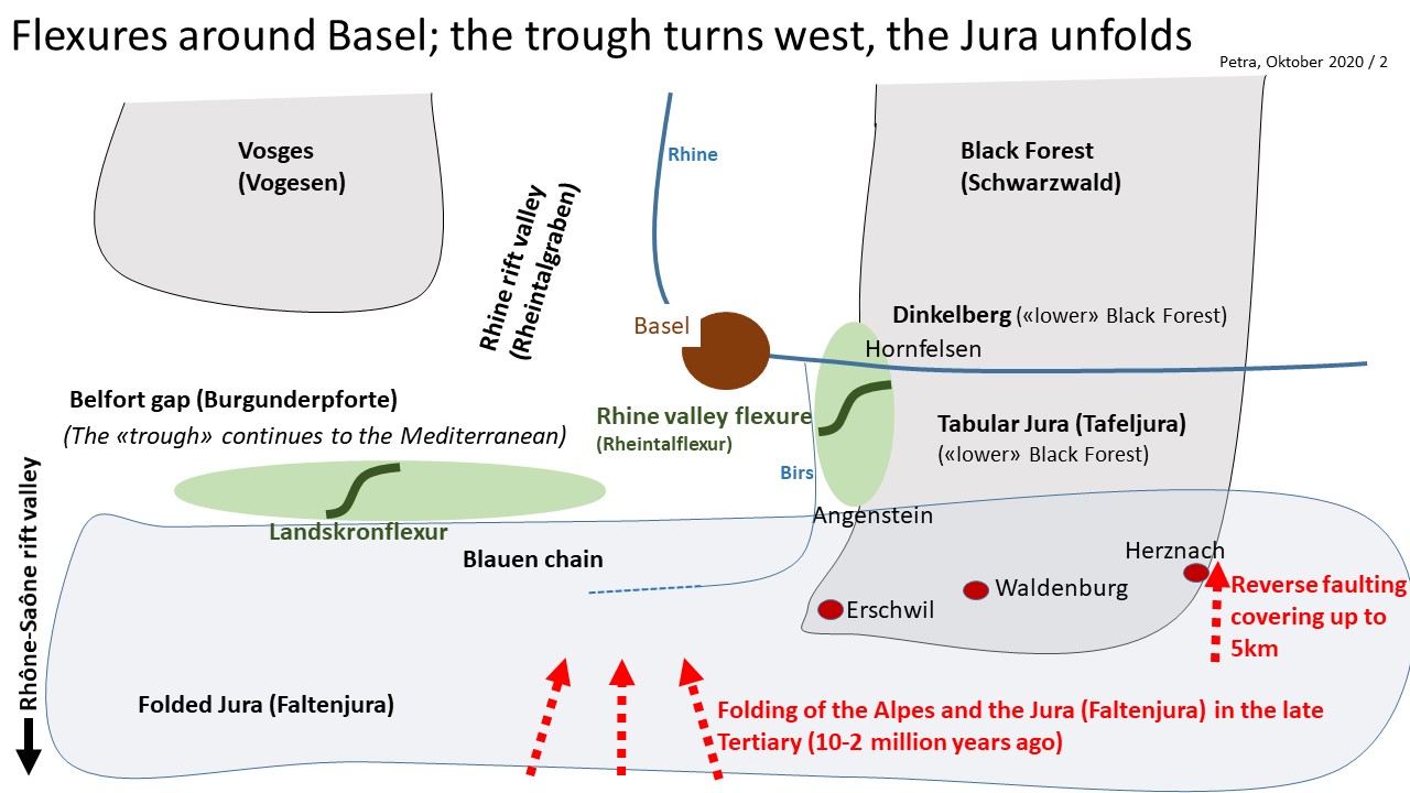
Source: My own rough drawing to understand the descriptions on https://www.regionatur.ch/Orte/Naturraeume-Flusslandschaften/Oberrheinische-Tiefebene (very much simplified)
Later, 10 to 2 million years ago, the Alps and the Jura Chain (Faltenjura) were unfolded, and they covered part of the “old” Tabular Jura by some 5kms. This is called “reverse faulting”.
The Alps and the Jura were unfolded, when the European plate slid under the Adriatic/African plate. This is a simplified model of the collision of the two plates.
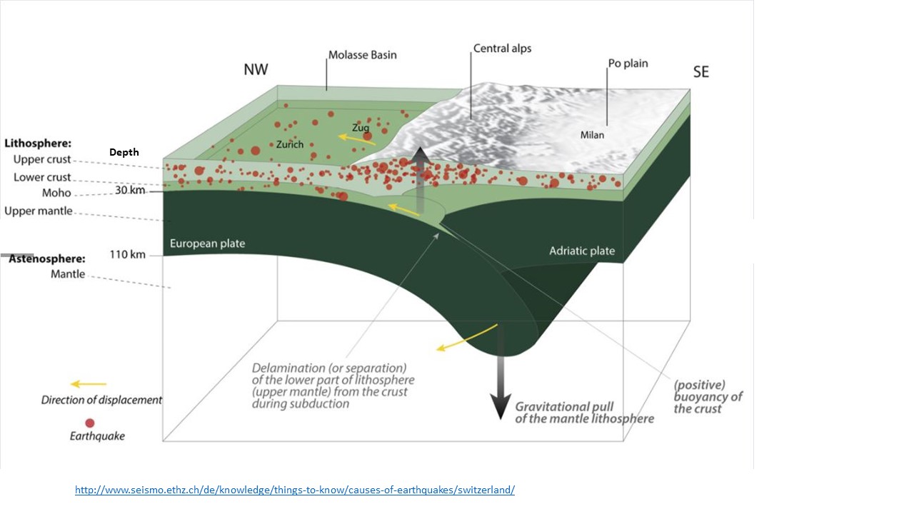
Source: Website ETH Zurich, knowledge about earthquakes
Laubscher points out that the plate border is not a “straight line”, but it stretches along 2000km, from the Atlas mountains in Africa to the Alps; Basel lies at the northern edge of this plate border “zone”. The convergence is still going on today: The European Plate pushes from North West and the Adriatic/African Plate from South East.
So, what might be the cause for the seismic activity around Basel and for the 1356 earthquake?
Let us recall the controversy I came across about the reasons of the earthquake of 1356 (as stated in my former blog):
- At high school, I understood from our teacher, the Rhine Rift Valley and in particular the “Rheintalflexur” had caused the earthquake of 1356. The Birseck is, where in Meyer’s map much of the historically reported severe damages seem to have been reported, but not all.
- Hans-Peter Laubscher, “Zur Geologie des Erdbebens von Basel 1356” (in Werner Meyer, “Da verfiele Basel überall”, Schwabe Verlag Basel 2006) says that the seismic activity around Basel is probably the result of the convergence of the African and the European tectonic plates that “waked up” various fault lines around Basel. This would explain the fact that further serious damages had been reported beyond the Birseck, Blauen and Gempen.
Laubscher presents this map of the rift valley, along with the fault lines he is aware of and the pressures going on.
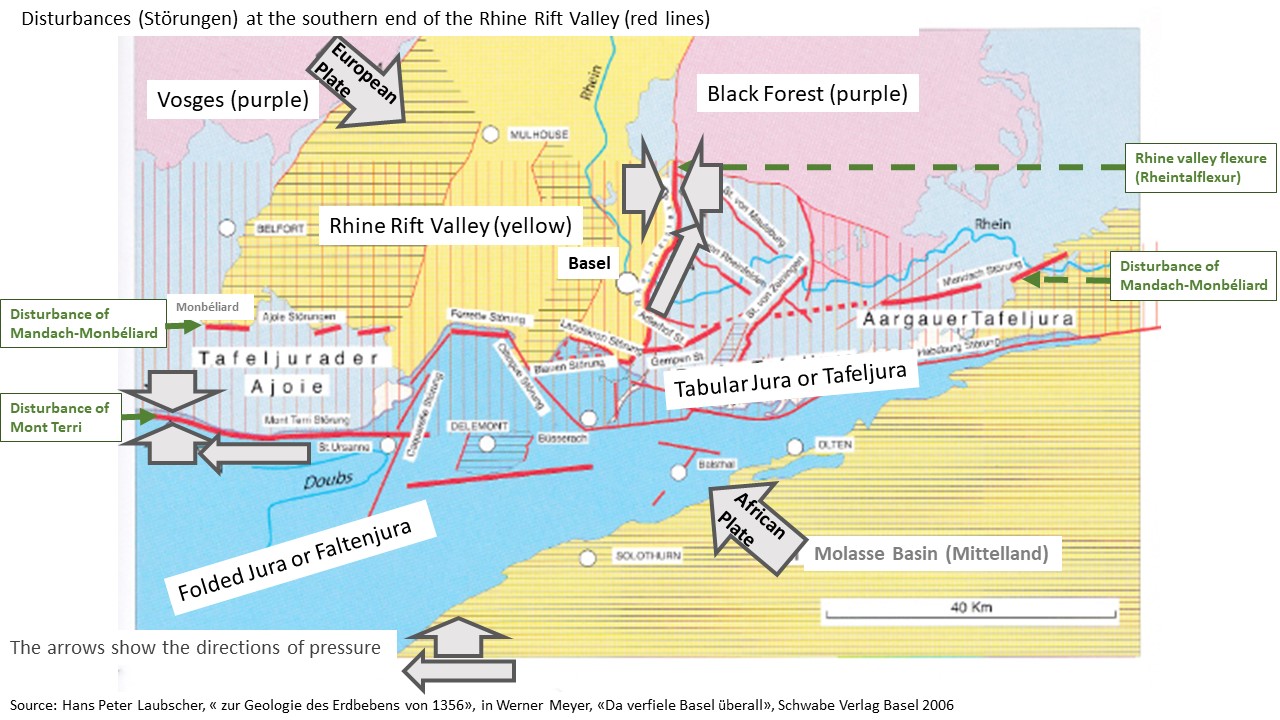
Source: Hans Peter Laubscher, “zur Geologie des Erdbebens von Basel 1356”, in Werner Meyer, “Da verfiele Basel überall”, Schwabe Verlag Basel 2006
As I understand Laubscher’s explanations, some fault lines such as the Rheintalflexur have been caused by the emergence of the Rhine Rift Valley (150-200 Mio years ago), but some other fault lines are much older, from 250-280 Mio years ago; at that time another earlier rift valley emerged (so called “permo-carbon trough”, see also Huggenberger), leaving “older” disturbances such as the Mandach-Monbéliard and the Mont-Terri. Laubscher says that the (older and newer) fault lines around Basel can be reactivated under new pressures.
The convergence of the European and the African plates is such a “newer” source of pressure (see the arrows showing the pressures executed by the plates). Still today, the plates converge at 8mm/year. Most of this convergence is currently being absorbed south of the Alps, where the seismic activity is much higher than north of the Alps. The Rhine Rift Valley fault lines and the older disturbances (such as the Mandach-Monbéliard or Mont-Terri lines) are areas of weaknesses that can react, when the tectonic plates of Africa and Europe rub against each other. Laubscher believes that this was the reason for the earthquake in 1356: The lesions around Basel reacted to the convergence of the tectonic plates (p.212). As a matter of fact, the pattern of damages reported historically pretty much follows the (older) Mandach-Monbéliard and Mont-Terri disturbances. In case the destructions reported historically are not complete and there were more destructions north of the “Meyer’s ellipse”, then the Rheintalflexur with its north-south orientation could also have made their contribution, as Laubscher points out.
On the geological map, arrows indicate the pressures along the Mont Terri Line and the Rheintalflexur. There is convergence (double arrows facing each other) as well as some sideward pushing (single arrow). The complex pattern of pressures is due to the fact that the convergence of the European and the African plate does not act at a right angle upon these fault lines. This makes predictions about seismic activity expected around Basel difficult.
While Laubscher says that at Basel severe earthquakes happen less often than south of the Alps, “less often” does not exclude another serious earthquake to happen again. In 660 years, the geology has not changed that much, when I think of the millions of years that count in geology. As my mum, the geologist, had rightly pointed out to me, when I was nine years old.
Well, I am not a geologist and I may not have consulted the latest research results. I have interpreted the sources I had at hand, and the basic story with the tectonic plates and the faults activated by their rubbing against one another causing earthquakes makes sense to me.
Due to the pandemic of this year 2020, I will continue to walk mostly around Basel in the next months. It is amazing, how much I discover so close to my home. I intend to follow up on the geological evidence of the flexures around Basel. What I also always find amazing, are all these border stones along the hiking paths and in the woods that tell us about the world history that the area around Basel was part of. Being confined at home opens the eyes for what is so near.
Sources:
- regionatur.ch describing the Oberrheinische Tiefebene
- Werner Meyer: “Da verfiele Basel überall”, Schwabe Verlag Basel, 2006
- Earthquake country Switzerland, ETH Zürich
- Bundesamt für Energie BFE, “Charakterisierung des geothermischen Reservoirs Riehen“, Dezember 2010, Forschungsprogramm Geothermie.
- Peter Huggenberger, Jura-Tektonik, Vorlesungsunterlagen Oktober 2015; he says that the permo-carbon troughs are even older, namely 320 to 250million years, instead of 280 to 250 million years, as Laubscher states.

[…] Let us do so after having thought about the earthquake of 1356 and the emergence of the Rhine Rift Valley (Rheintalgraben). […]