Hermann Radzyk painted the Canal Grande in Venezia in 1910 – where?

Just after having finished his studies at the Königliche Akadamische Hochschule der Bildenden Künste in Berlin, my grandfather Hermann Radzyk and his wife Helene travelled to Venice. My grandparents were a newly married young couple then.

My grandfather painted “Canal Grande, Venezia 1910”, signed Hermann Radzig-Radzyk; owned privately.

Hermann Radzyk sold the picture to the cousin of his wife Helene; perhaps it was also a gift within the family.

Where was the easel? I looked for a garden along the Canal Grande using Google Maps, but without result. I knew, more systematic searching is needed to find the location of the easel.


Later I located the place, where my grandfather put down his easel in 1910

One afternoon in December 2025, I searched using Google maps and found that my grandfather’s easel stood on the Fondamenta del Traghetto San Maurizio looking across the Canal Grande at the palaces next to the Rio de San Vio.

Let me tell you, how I found out, where my grandfather had put down his easel.

  • First, I looked for something typical on the picture; well, what about the bridge just before the side channel enters the Canal Grande?
  • Next I followed the Canal Grande on its long course (wiki entry for Venecia says, it is 4km) to find the side channels with a bridge near the mouth. Voilà, a bridge near the mouth… that fits for the Rio de San Vio.
  • Across Canal Grande, I notice a platform. It is called Fondamenta del Traghetto San Maurizio. This is the platform, where my grandfather painted, as becomes clear by analyzing Google Street Views.

Look at the picture of my grandfather: The platform, where he stands, ends with a house that  has a door arch and a bricked white edge. Google Street View today shows a  house with a door arch and a bricked white edge, what a good match. Well, something like door bells have now been added next to the door, and the dark red colour of the wall has become brighter… but more than a hundred years have passed since then. The stone columns of the railing still have the same form as in 1910. Sure, the easel stood on Fondamenta del Traghetto San Maurizio.

What about the palaces that my grandfather painted across the Canal Grande next to the Rio de S. Vio? Have they changed much? No, they can be identified on Google Street View today, including the garden between them.

The first two houses just next to the mouth of Rio de S. Vio have practically not changed since 1910. The first house still has an oriel and a window with two arches on the first floor; its colour has become more yellow today. The structure of the second house is also unchanged: Still the same arched gallery just above the water, the two side wings framing the steps to access the Canal Grande, the arched window lines with balustrades on the two upper floors. Just the colour has changed, the house is now cleanly white.

From the Fondamenta, Google Streets View provides a second panoramic view which allows to look more into Rio de S. Vio and more upstream beyond the garden.  Street View shows no sun blinds above Rio de S. Vio; my grandfather had painted two sun blinds here; may be he painted on a hot summer day, and the Google Street View photographers were here on a less sunny day. The garden is  also on the picture of my grandfather, and the houses behind the garden can be recognized still today.

The second focus of Google Street View makes one major change clear: My grandfather had painted steps providing access to the channel; they have disappeared today; they have been replaced by a continuous railing. When virtually turning around with Street View, I can see that boats on the Canal Grande are now accessed on the opposite side of the Fondamenta del Traghetto S. Maurizio using a wooden catwalk.


The history of the picture “Canal Grande, Venezia, 1910”

The picture of Venice is owned by a distant cousin of mine (let me call her Cathy). A cousin of us (let me call him Hans) told Cathy, who Hermann Radzig-Radzyk was: “Hermann Radzyk (who signed as Hermann Radzig-Radzyk) was an artist in our family and the grandfather of our cousin, Petra. His wife (and Petra’s grandmother) was Helene Radzyk. Helene and your grandmother were cousins; they were friends and went to school together, in Lüneburg; Helene’s father was the director at the agriculture school. Your grandparents either bought the picture from Hermann and Helene Radzyk, or they received it as a gift.”

I visited Cathy a year ago. It is wonderful to meet (even distant) relatives for the first time and to discover similarities such as the same curls in our hair, similarities that remain though it was our grandmothers that were cousins.

We took the picture of Venice from the wall. This is how I found out that it was painted in 1910.

My cousin Cathy always thought, her grandparents had bought the picture as a souvenir, when travelling to Venice as a young couple. But no, it was painted in the family, as our cousin Hans had told her.

While Cathy lived in the Federal Republic of Germany, her grandmother lived in Perleberg in the former GDR; the painting of Venice was with Cathy’s grandmother, in Perleberg. When Cathy’s  grandmother died in the 1960’s, Cathy travelled to Perleberg to settle the estate. An attorney told her that she had no right to the inheritance, because she had left the GDR as a student. “Okay, nothing to be done”, she said, ” but could I then just take the family baptismal bowl with me, as in our family, we have the tradition of engraving the name of each new-born child on it.” “Are you pregnant?”, the attorney asked. “Yes, I am expecting a daughter”, Cathy answered. “Well then”, the attorney answered, “you can renounce the inheritance in favour of your unborn daughter, as she did not leave the GDR on purpose.” And that is how the picture of my grandfather came to the Federal Republic of Germany and into Cathy’s house.


My 40-year-old memories of Venice – perhaps I will return one day

I was in Venice in May 1987, almost 40 years ago. At that time, I wrote a diary that I am looking at now. I read that after having arrived at the train station, we took the Vaporetto along Canal Grande to Academia to get to our hotel Americano in Calle Nuova San Agnese. Google Maps tells me that Calle Nuova San Agnese is just behind the houses and the garden that my grandfather painted in 1910. Well, 40 years ago, I did not know my grandfather’s picture, and nevertheless I was so close to it and to my grandparents. It is an almost transcendental feeling.

Perhaps I should return one day in order to consciously look at the Canal Grande that my grandfather has painted and to relive my memories of Venice from 40 years ago.


Sources:


The book about the artist Hermann Radzig-Radzyk published

As the granddaughter of the artist Hermann Radzyk (1879-1945), I published the book about my grandfather’s life and work in September 2025. The editor is the Kultur- und Heimatverein Kleinmachnow e.V.

Als Enkelin des Kunstmalers  Hermann Radzyk (1879-1945) publizierte ich im September 2025das Buch über Leben und Werk meines Grossvaters. Der Herausgeber ist der Kultur- und Heimatverein Kleinmachnow e.V.

ISBN: 978-3-033-11258-2.

The cover shows the picture”Panne”, signed Hermann Radzig-Radzyk, painted between 1926 and 1928 in Belgium (North Sea beach).

Das Deckblatt zeigt das Bild “Panne”, signiert Hermann Radzig-Radzyk, gemalt zwischen 1926 und 1928 in Belgien (Nordseestrand).


The book is the result of my five years’ research following my grandfather’s footsteps

Five years ago, I started collecting information about my grandfather. For example I studied the family archive (a box with letters and documents), I visited archives in Berlin (found personnel records there), I contacted galleries and auction houses (again and again they sell paintings from inheritances), and I learnt from the Brandenburg Memorial Centre, when he died, namely on September 18 1945 in Sachsenhausen.

My grandfather primarily painted landscapes and cities. I wanted to understand where, I looked for the places in the internet and I travelled there. When I stood at the place, where my grandfather had created one if his paintings, I felt close to him, to my grandmother and to their daughter (my mother). For instance in Bohemia near the Schneekoppe or in Silesia at the Euldörfel and near the Silberberg viaduct.

In the book you  find more than 70 paintings by Hermann Radzyk and his biography(family, education, career as a teacher and artist). The introduction provides the historical context for his life and tragic end.


Das Buch ist das Ergebnis von fünf Jahren Forschung auf den Spuren meines Grossvaters

Vor fünf Jahren begann ich, Informationen über meinen Grossvater zu sammeln. Zum Beispiel studierte ich das Familienarchiv (eine Kiste mit Dokumenten und Briefen), ich besuchte Archive in Berlin (fand dort Personalakte), kontaktierte Galerien und Auktionshäuser (verkaufen immer wieder Bilder aus Nachlässen) und erfuhr von der Stiftung Brandenburgische Gedenkstätten, wann er gestorben ist, nämlich am 18. September 1945 in Sachsenhausen.

Mein Grossvater malte meist Landschafts- und Stadtansichten. Ich wollte verstehen wo, suchte die Ansichten im Internet und reiste hin. Wenn ich wieder einmal dort stand, wo mein Grossvater gemalt hatte, fühlte ich mich nahe bei ihm, bei meiner Grossmutter und bei der Tochter (meiner Mutter). Zum Beispiel in Böhmen bei der Schneekoppe oder in Schlesien im Euldörfel und am Silberbergviadukt.

Im Buch findet Ihr  mehr als 70 Gemälde von Hermann Radzyk und seinen Lebenslauf (Familie, Ausbildung, Beruf als Lehrer und Künstler). Die Einleitung stellt sein Leben und sein tragisches Ende in den historischen Zusammenhang.


For example I found the locations of the easel for the pictures of the Schneekoppe, the Euldörfel , and the Silberbergviadukt
Zum Beispiel fand ich den Standort der Staffelei für die Bilder mit der Schneekoppe, dem Euldörfel und dem Silberbergviadukt

Schneekoppe, probably/wahrscheinlich 1927 (see/siehe blog schneekoppe


“Blick in das Glätzische Land” 1923 (see/siehe blog euldörfel)


“Der Viadukt, Silberberg, Eulengebirge” 1924 (see/siehe blog silberberg)


May the paintings of my grandfather enjoy my family, friends, and many more interested readers
Möge das Buch meine Familie, Freunde und viele weitere geneigte Leser erfreuen

A family friend wrote in a letter to me in 2024: “I believe, your grandfather has never been as alive as he is now, when he has obviously taken possession of you. Enjoy it! … Marion would be happy, and since she can no longer write, I am doing it for her.” (Marion is the daughter of Hermann Radzyk, and she is my mother).

Eine Freundin der Familie schrieb mir im Jahre 2024: ” Ich glaube, Dein Grossvater war noch nie so lebendig wie jetzt, wo er offensichtlich Besitz von Dir ergriffen hat. Freu Dich dran! … Marion wäre glücklich und da sie nicht mehr schreiben kann, tue ich es stellvertretend.” (Marion ist die Tochter von Hermann Radzyk, und sie ist meine Mutter).


Looking for the farm that Hermann Radzyk painted at Blankensee

My grandfather Hermann Radzyk (Hermann Radzig-Radzyk) painted this farm full of life about 90 years ago.

The farm house is “in Blankensee (Mark)” and was painted in 1934 and 1940.

The painting was above the sofa in the living room of our parents’ house. It accompanied our evening discussions, sometimes with guests. As girls, we used it, when our teachers – many years ago – asked to describe a painting; there is much to see: the house, the barn, the cock with the hens, one hen on a dung heap, some geese, a birdhouse in the tree… in the background the blue lake…

To look for the farm, I drove to Blankensee in August 2024. I found this green washed house that could be it; I just look at it from the other side (i.e. from behind the fence on the painting).

If this is the farm, a second floor has been added under the roof, now a holiday apartment on offer in the internet. The barn has become a horse stable with solar panels on the roof. I could not verify my assumption, as I could not reach the owners.

Let us see, how I found the green washed house.


My investigations at Blankensee 

To find the farm house of the painting, I drove to Blankensee twice. The village and the lake with the same name are located in the Nuthe-Nieplitz valley, about 40km south of Berlin.

First I went there on a sunny Saturday. I parked my car near the village church.

Blankensee is a lively small village, very popular with Berliners who come for a walk in the nature reserve around the lake.

A small museum? May be they have historical photos of the village? “Yes”, the manager of the museum tells me, “we have a collection of old photos and we are currently bringing order into it; leave a photo of your painting, we will tell you, when we find the house your grandfather has painted.” So far, I have not heard from the museum.

The lake can be seen from my grandfather’s farm house? Then I should be able to see the house from the lake side. I  access the lake on the wooden gangway “Holzbohlensteig”.

From here I cannot see any houses from the village Blankensee. I am confused.

What now? I drive to Körzin, a hamlet on the opposite western side of the lake.

In this charming restaurant garden, I enjoy a delicious trout with potatoes and cucumber salad.

Encouraged again, I return to investigate the next question: Though the village Blankensee is not bordering the lake Blankensee, which houses are closest to the lake? The red circle below shows, where the houses are closest, and here I find a path approaching the lake.

Source: Google maps. The path going towards the lake is in the red circle.

I enter the path and walk in direction of the lake.

At the end of the path, bushes and the sign “private property” prevent me from going further. I turn around and notice this green washed house and the horse stable. Horses walk around in the paddock.

Below, on the map, the green washed house is marked by the small red circle. It is a holiday apartment, and the website shows that from the two big windows the lake can be seen across the horse paddock – as on the painting of my grandfather.

Source: Google maps; the green washed house on the Blankenseer Dorfstrasse is marked with the small red circle

May be this is my grandfather’s house just seen from the opposite side? The green washed house has a similar structure as the house on the painting, just with an attic added under the roof . The barn, also seen from “behind” on my photo, has been modernized with solar panels.

There is one difference though. From the holiday apartment the opposite shore line can be seen, while on my grandfather’s painting, there is just the blue lake and no shore line. Is that possible? Yes, it is possible. From the window of the holiday apartment, the view goes across the short side of the lake (more eastwards), while the painting shows the view from between the house and the stable, and this view goes across the long side of the lake (more southwards, see red arrow below).

Source: Google maps; the red arrow shows the view of the lake from my grandfather’s easel.

Second, I return on the following Wednesday to find out more.

Standing in front of the green washed house in the Dorfstrasse, I hear the humming noise of a gazoline lawn mower in a nearby garden. A retiree, born at Blankensee in 1941, is mowing his lawn. “1940’s? I was too young to remember”, he says, “the fisherman Protz lived in the green washed house. His daughter got married, and the couple stayed here until 2016. They sold the house. The new owners converted it into the holiday apartment.”

I try to contact the new owners by ringing the door bell, by dropping a letter in the letter box, by sending an email. However, no answer. No way to verify that the green washed house is the farm house my grandfather painted. It remains a hypothesis, but it is well possible, in my opinion even likely.

Enough, I cannot find out more. Next, I explore Blankensee and its surroundings, another place that my grandparents have guided me to.


Some history in the museum of Blankensee

It was the village priest Peters who in the 1940s/50s laid the basis for the museum of Blankensee; he was a hobby archaeologist. He gathered former farming, crafting and fishermen objects. With the farmers, he worked in the fields, where he found objects from prehistoric times. Thanks to the archaeologist-priest, the museum can document the history of Blankensee: Stone age tools, the arrival of the Slavs (9/10th century), the settlement by the Germans (property of the monastery of Zinna in 1307), the rule of the Saxons (from 1333) and of the Prussians (after 1815), the fief of the family Thümen (since 1446), the arrival of the Soviets in 1945, the years of the GDR and the years after the German reunification of 1989.

In 2007, Blankensee celebrated its 700-years’ anniversary (1307 to 2007). The coat of arms alludes to fish and to birds.

One example of the exhibits: The grim catfish looms next to the fish trap. Eels and trouts are also common in the lake.

In the former barn, the museum runs an excellent restaurant, where I have another fresh trout.


The nature reserve and the lake

The lake Blankensee is a nature reserve – swimming is forbidden. Panels explain the fauna and flora found here.

Eel is a specialty, it can be bought at the smokehouse in the village.


Castle of the family Thümen, now an event center

The famliy Thümen owned Blankensee from 1446. In 1701, they built the charming small castle…

… with a garden full of romantic corners (another work of the garden architect Peter Joseph Lenné).

The castle is now an event centre and the park is open for the public.


Friedensstadt

The retiree I met, when he was mowing his lawn, lives in Friedensstadt. “You do not know Friedensstadt?” he asked me with astonishment, and he added: “It is a wonderful place to live, it is not far away, you should have a look.”

I went there and was impressed.

Friedensstadt was founded by Joseph Weissenberg in 1920. Just after the traumatizing World War I, it should become a place of peace for the Christian Johannes Community. It was conceived as a cooperative for residence and work, with social institutions and a religious background. 15 years later in 1935, Friedensstadt counted 400 residents.

Now, history shook up the place. First, the National Socialists took over, in 1945 the Soviets (Garnison Glau). The Russians left Friedensstadt in 1994. The city was given back to the Johannes Community.  In 2020 they celebrated their 100-years’ anniversary.

The Frieda Müller Haus was built in 1930; it was the old people’s home. Today, it contains apartments and meeting facilities, as the panel says.

1934 the school was built in the Bauhaus style. Temporarily, it is used for religious services; it is planned to be converted into a school again, as the panel says.

14 families live in the “10 families house” from 1930 that has also been restored.

Friedensstadt is located off the beaten track. Citizens who want to go to Blankensee, Trebbin, or farther, wait on the “Mitfahrer-Bank”, until a car comes by and gives them a lift as a Mitfahrer or, literally, as a “co-driver”.

When I pass by this bench, no one is waiting here, hence I continue my way alone and return to Berlin.

Thank you, my grandparents, you have shown another nice spot of Germany to me.


Sources (all accessed in September 2025):

Finding out, where Hermann Radzyk painted a market: Heydekrug

The “mysterious” market painted by Hermann Radzyk

My grandfather, Hermann Radzig-Radzyk, painted a market near a creek. He signed the painting, and he gave it neither a title nor a date.

Searching again and again, I found it was the market of Heydekrug, as this photo from about 1925 shows. 

Source: https://wiki.genealogy.net/Markt_in_Heydekrug, accessed in april 2025.  

Up to the First Word War, Heydekrug belonged to Eastern Prussia, now it is called Silute and is part of Lithuania (Litauen).


Two more paintings from former Eastern Prussia (now Lithuania)

Not far from Heydekrug, my grandfather visited Purwin (Nidden) on the Curonian Spit. The first painting is signed and dated to 1928; it has no title.

The second view of Purwin is dated to 1932. The title on the back says “Fischerhäuser auf der Kurischen Nehrung (Purwin), (fishermen’s houses on the Curonian Spit (Purwin).”

Very similar postcard views can be found on https://www.bildarchiv-ostpreussen.de/ (numbers 46466/7 and 130909).


How did I find the market at Heydekrug?

Let me tell you, how I found, where my grandfather had painted the market.

In the beginning, I had absolutely no idea, where this market could be. Perhaps in Belgium? In Belgium, I looked for markets on old postcards – without success.

Independently, I wanted to know, what paintings my grandfather exhibited at the Grosse Berliner Kunstausstellung (Great Berlin Art Exhibition). I checked all catalogues from 1910 up to 1945. For 1932, I found the painting “Marktschluss in Heidekrug (market closure at Heidekrug)”; it had the number 239. I remembered the painting of the market that I had not localized so far. Is this perhaps the market I am looking for?

I searched for “Heidekrug” on googlemaps and found a village with this name east of Berlin. But Heidekrug east of Berlin had no market near a creek. I looked for old postcards of Heidekrug; no, my grandfather’s market was not here. I search again and again for “Heidekrug”, and once, by chance, google search decides to show the genealogy Website with HeYdekrug to me. Could it be that there are two ways to write “Heidekrug”? Now, I search for “Heydekrug”, and this time, the genealogy website comes up with the old postcard that shows the same houses that my grandfather has painted. 


I feel like the three princes of Serendipity: The painting of the market – no idea from where. The catalogue of the Grosse Berliner Kunstausstellung – found one painting with the title “Marktschluss in Heidekrug”.  Heidekrug near Berlin – not a good match. But Heydekrug on the genealogy Website for descendants from former Eastern Prussia – this is it!

Heydekrug, now called Silute, in Lithuania is located on  the creek Sysa. The Sysa is navigable up to Heydekrug/Silute and from here, it is possible to get to the Curonian Spit by boat. 

Perhaps, my grandfather painted the market, when he was travelling to Purwin and the Curonian Spit. He probably had to stop at Heydekrug; it was a train stop on the route from Königsberg to Memel. From Heydekrug, he took the boat to get to the Curonian Spit and to Purwin.  


The Curonian Spit – a popular spot for artists

The Curonian Spit (Kurische Nehrung) was a popular spot for artists. At Purwin (a district of Nidden), the guesthouse Blode started to be visited by artists in 1867. In the beginning of the 20th century, members of the Brücke group stayed here, amongst them Max Pechstein. Thomas Mann owned a house at Purwin, where he spent his summers from 1930 to 1932.  Google images is full of paintings that Max Pechstein has made at Purwin. In addition, I found the PDF reprint of the Landsmannschaft Ostpreussen with paintings of various other artists such as Corinth and Mollenhauer.  

Popular spots of artists attracted my grandfather again and again for his study tours (“Studienreisen”). I believe he looked for contacts and discussion partners. The PDF of the Landsmannschaft contains a photo of the artists’ corner in the guesthouse Blode, where my grandfather might have joined the conversations between artists.   

Let us look at my grandfather’s paintings again. The house, the pine tree and the fence on the right hand side of the fist painting of 1928…

… appear also in the middle of the second painting of 1932, just from a different angle.

In the year 1930, Hermann Radzyk gave two paintings from Nidden to the Grosse Berliner Kunstausstellung: “Fischersiedlung (fishermens’ settlement” (number 331) and “Am Nidderhafen (near the port of Nidden)” (number 332).


Would it be an idea to travel to Lithuania?

Jörn Baford writes in the Kulturforum that since the 1990’s, Nidden (today Nida) on the Curonian Spit attracts tourists again and the house of Thomas Mann has become a cultural centre. Perhaps I should plan to visit Lithuania soon? It is another travel destination that my grandfather is pointing me to.


Sources:


Hermann Radzyk painted the church and the train station of Geising

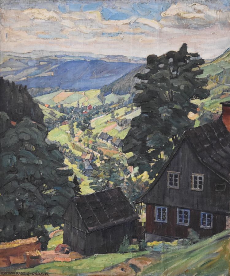
In 1932, my grandfather Hermann Radzyk created two paintings at Geising in the Erzgebirge (Ore Mountains), south of Dresden. 

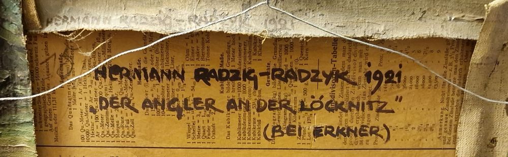
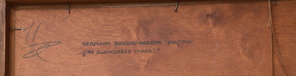
The first painting hangs in my home. At the back, it carries the title “Geising im Erzgebirge”, is signed with Hermann Radzig-Radzyk and dated to 1932. 

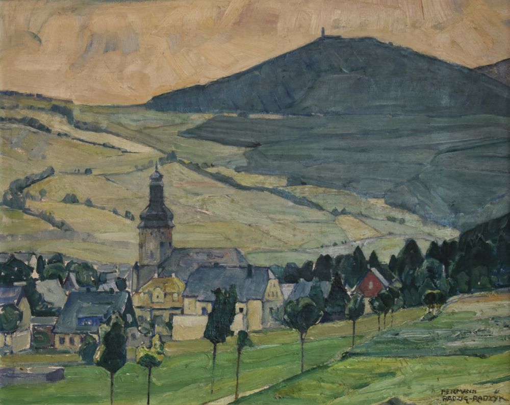
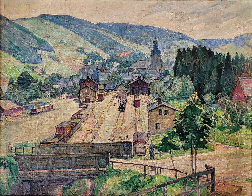
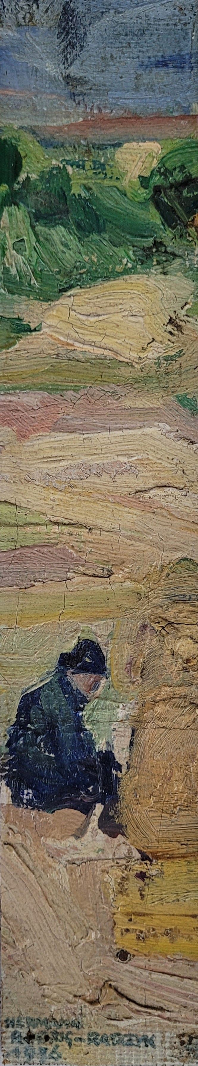
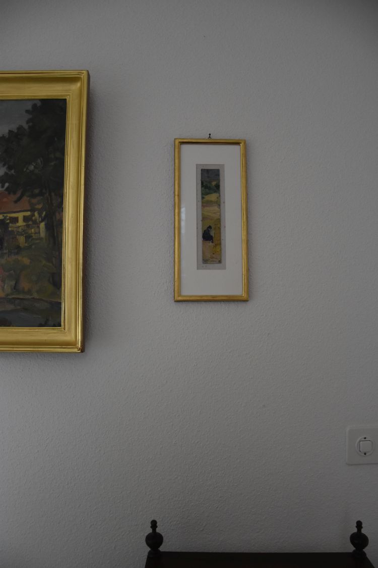
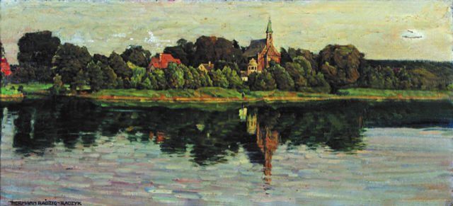
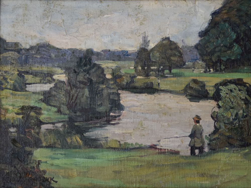
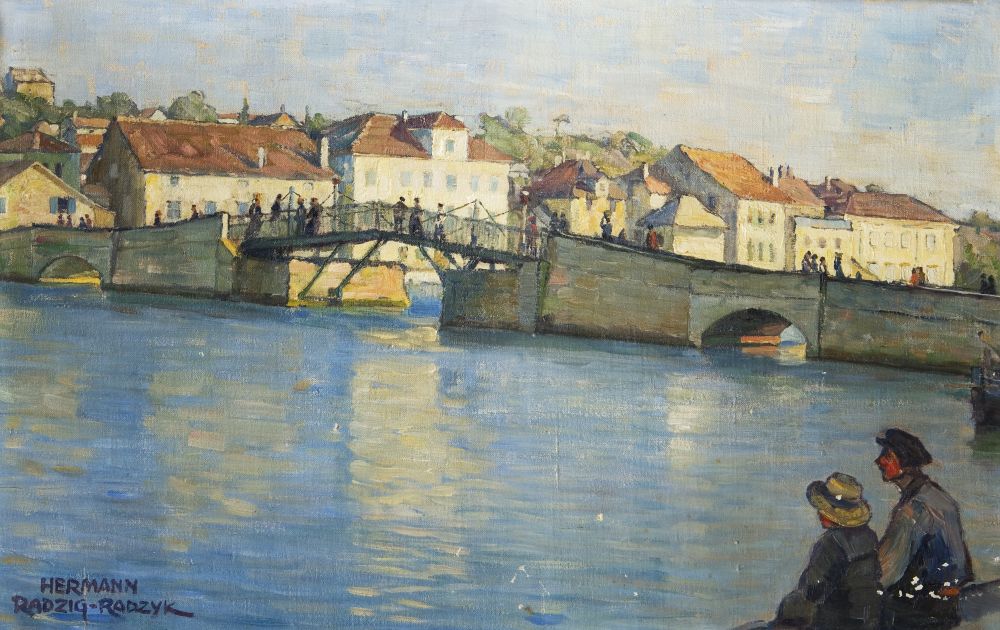
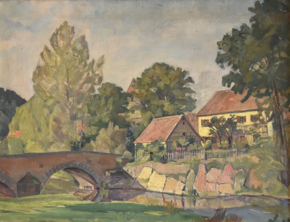
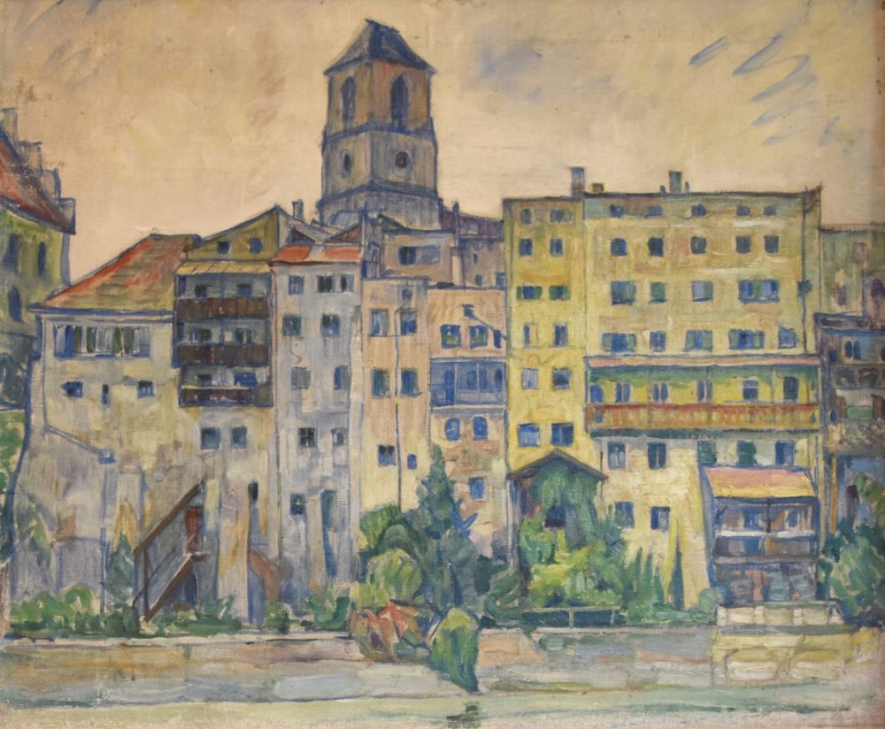
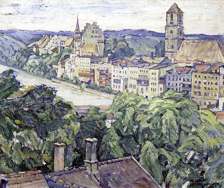
The second painting belongs to my sister. It has no title, is unsigned and undated. It shows the same church of Geising and must have been created in 1932 as well. 

The second painting has a daunting history. Let me tell you.

The painting decorated the living room of my grandparents in their house at Kleinmachnow, Haberfeld 5.

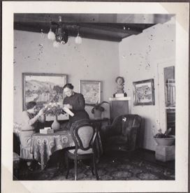
The photo of 1940 is from the wedding album that my mother assembled, when she, still called Marion Radzyk, met my father, Rudolf Peters. With her mother Helene Radzyk, she  arranges flowers, the painting hangs behind them. Furthermore her bust (she was then about 17 years old) stands in the corner. 

I came across the painting in the home of my sister. It had a sad look: No frame, dirty and damaged, some holes.  

In the Second World War, the house of my grandparents was damaged and surely this has caused the holes. After the War, Kleinmachnow was part of the Soviet Zone. When my grandmother died in 1953, my mother went to Kleinmachnow for the funeral. She described in her diary that she packed some of her father’s paintings and her bust in a bag and crossed the zone border to West Berlin without being stopped by the customs officers – luckily. I am pretty sure, this is how the painting of the Geising train station ended up in my mother’s house and later in our hands. 

I had the severely damaged painting cleaned and repaired by my gallery in Basel.

It shines again in fresh colours. Only now I take notice of the two ladies next to the bridge, my grandmother Helene with her daughter Marion – my mother.


How did I find out that not only the first painting (with  the title), but also the second painting (without the title) is from Geising?

The first painting carries the title “Geising im Erzgebirge”. This was easy. The old postcard illustrates my grandfather’s perspective with the mountain Geisingberg north west of the small city.

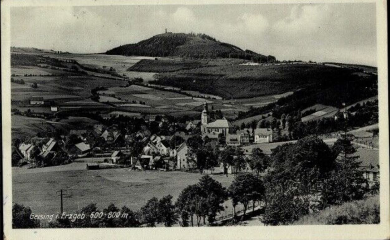
Source: Mail by the historian of Geising from May 8th 2024

The second painting carries no title. I guessed that the church is also at Geising. Googling, I found the postcard that clearly confirmed my guess.

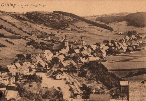
Source: Ansichtskartenlexikon, Stadtpartie, Bahnhof: Geising-Altendorf (Erzgebirge).

Consequently, I planned a stop at Geising, and end of April/beginning of May 2024, I booked a room in the hotel Ratskeller at Geising to look for the paintings.


Where did Hermann Radzyk put down his easel at Geising?

Let us tackle the first painting – church and mountain Geisingberg.

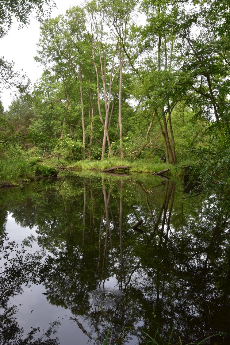
His easel was higher and more to the left than my photo below; between him and the village was a field with a footpath and a few small trees. Now the field is covered with newly built houses, and there are gardens with big trees. 

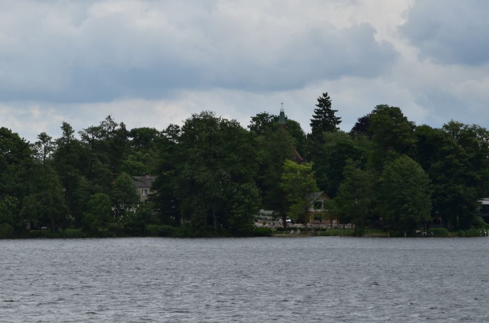
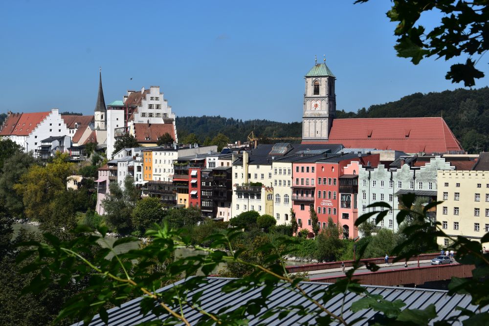
I walked uphill between the houses, and up to this point, I could see both the church and the mountain Geisingberg in the background. Going farther uphill to get to the location of the easel, the church and the mountain disappeared behind the houses, the gardens and the large trees. Today, Hermann Radzyk could no longer paint his perspective today. 

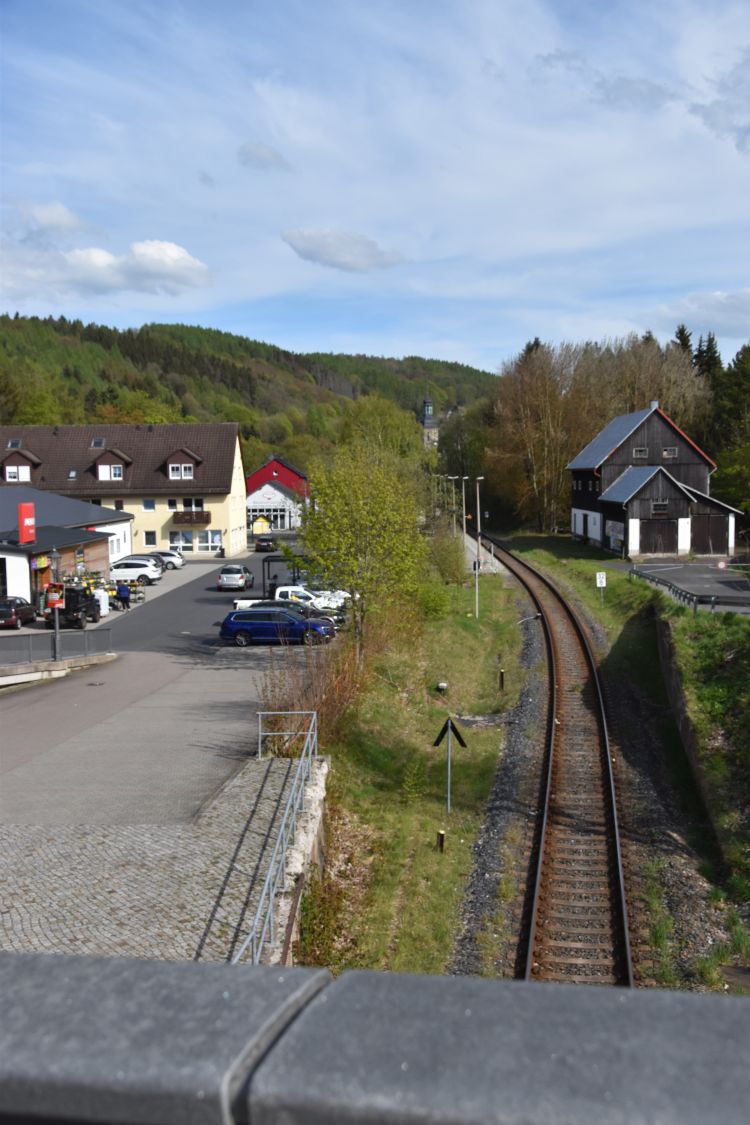
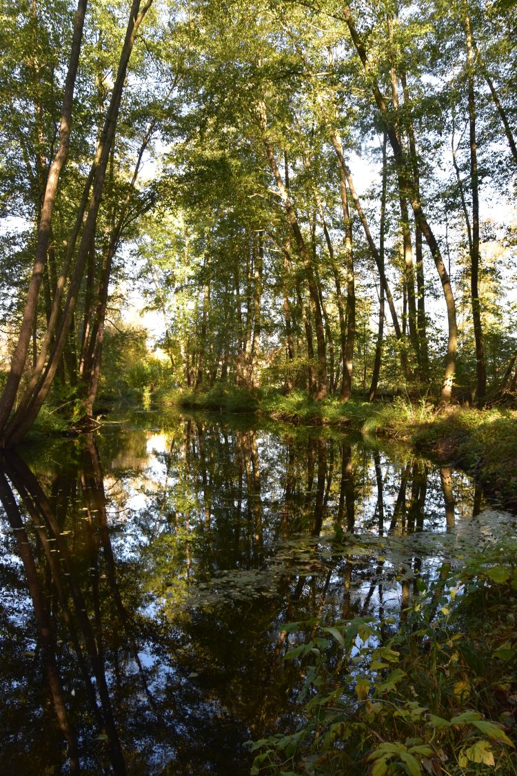
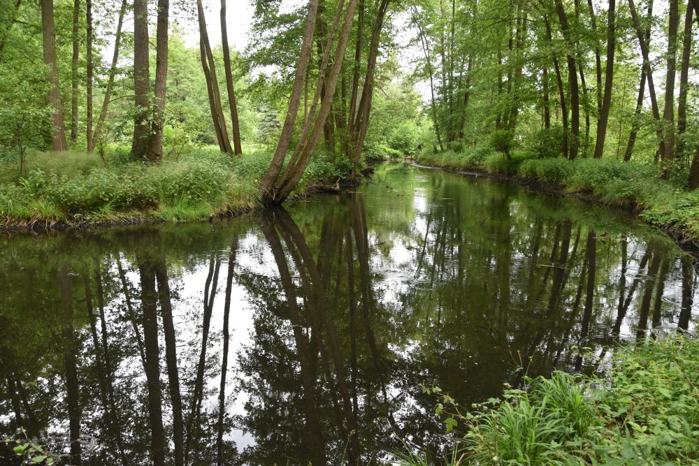
Also the second painting with the train station is no longer possible today.

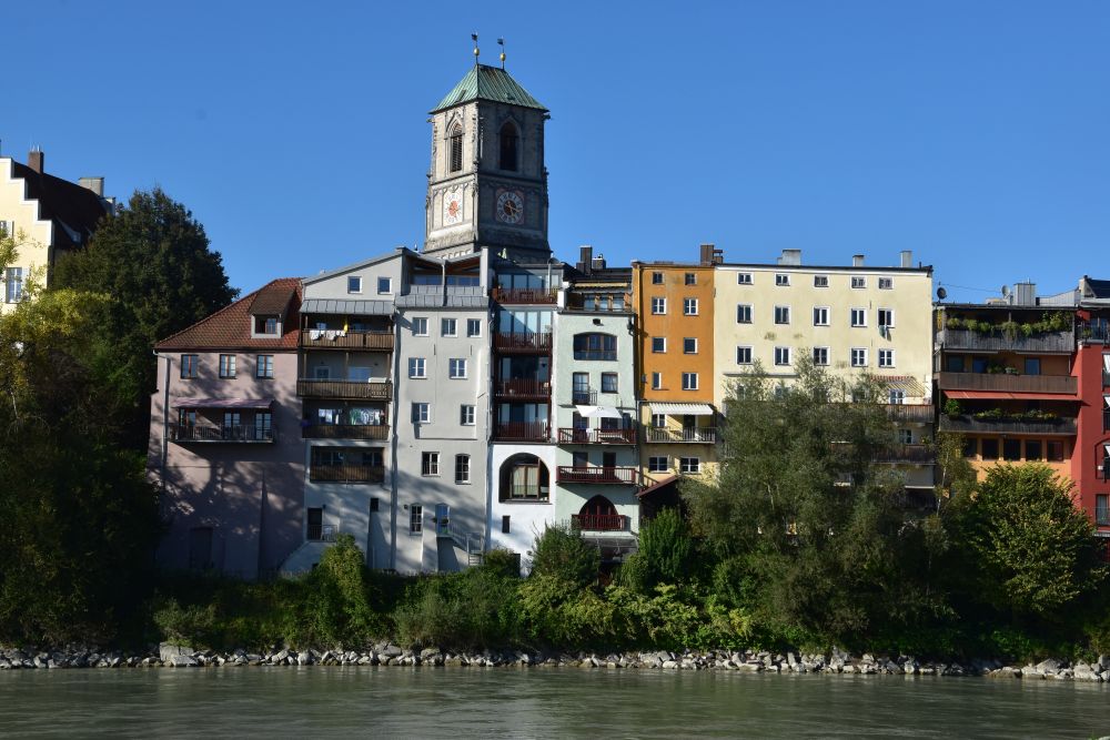
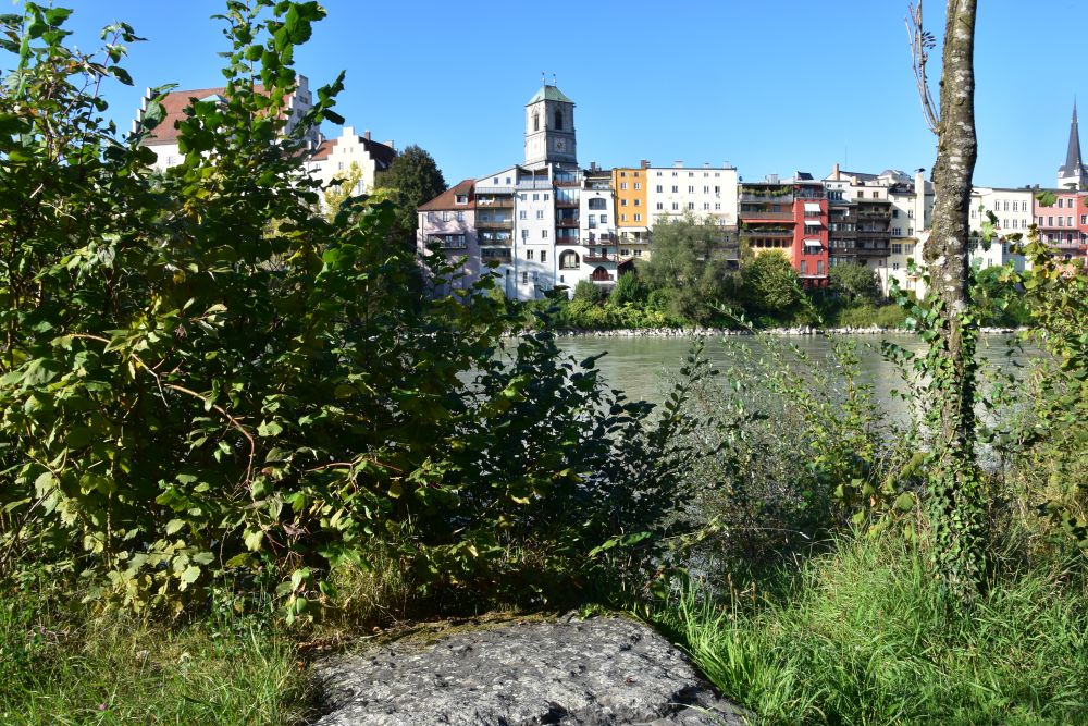
The train station looks different, the church in the background can barely be seen. The bridge is much larger. A busy road coming from Altenberg crosses the railway here. I am standing a little too low; my grandfather stood to the right of the bridge on the footpath leading to the mountain Geisingberg. 

On the hiking map, I marked the locations of the easel.

Source: Osterzgebirge zwischen Dippoldiswalde und Teplice (Teplitz), Wander- und Radwanderkarte mit Reitwegen, 1:33’000, Herausgeber: Sachsen Kartographie 2022.

The easel for the first painting (red circle) stood above Geising looking north-west towards the church and the mountain Geisingberg. The easel for the second painting (purple circle) was at the entry of the road from Altenberg to Geising above the bridge, looking south east towards the mountain called Hutberg. 

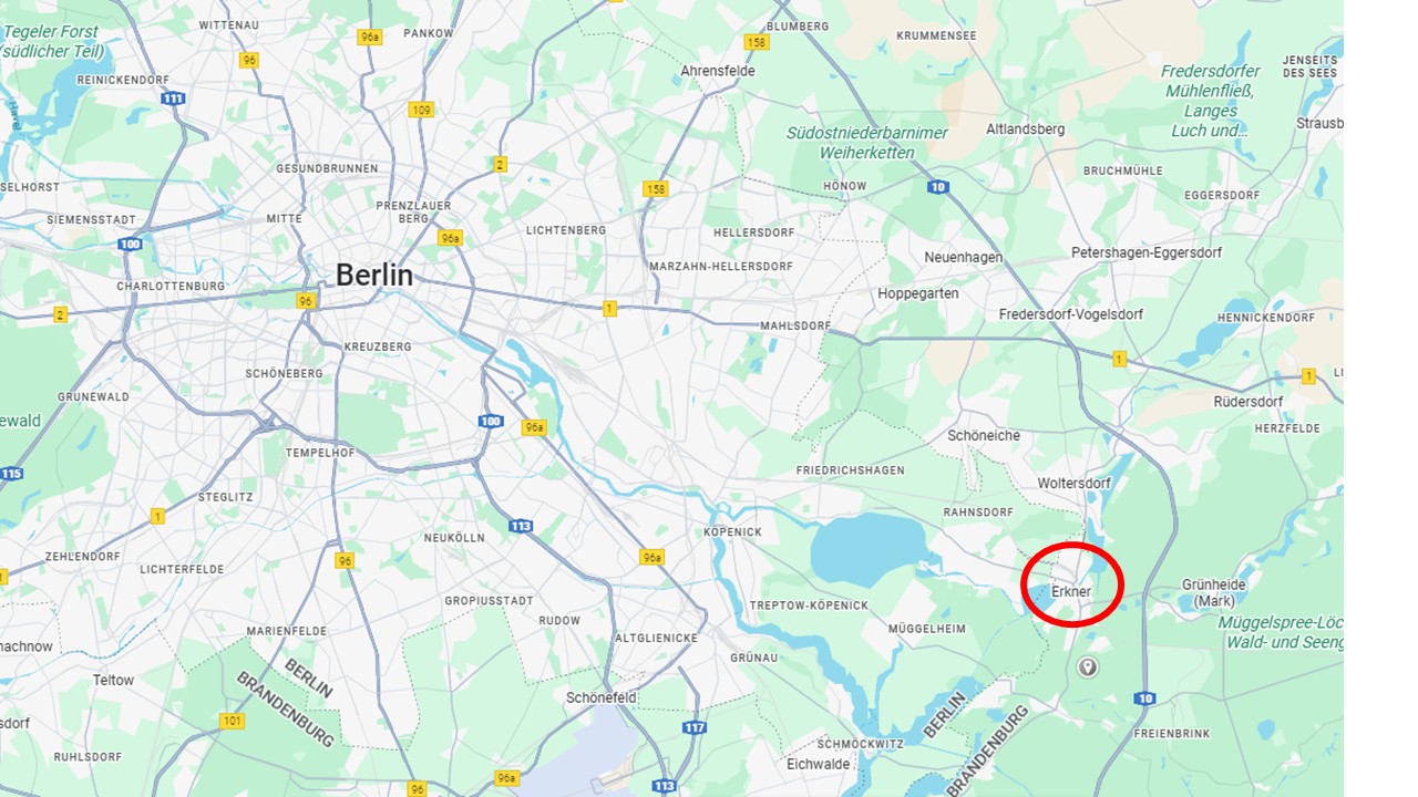
Geising is located 45km south east of Dresden, in the Erzgebirge (Ore Mountains) and at the border to Czekia. I have marked Geising with a red circle.


Why Geising, were there more artists at Geising?

While strolling through Geising, I met many friendly citizens. They noticed my camera and asked me: “What are you doing?” When I showed them the paintings of my grandfather, they gave me hints and told me about other painters at Geising.

Very proud they are of Heribert Fischer-Geising (1896-1984) From 1919 to 1961, he lived at Geising, and he integrated the city in his name. Not far from Geising, the castle Lauenstein hosts an exhibition of his paintings. Fischer-Geising painted landscapes and portraits. He was not only an artist, but also a ski teacher that won medals. For one of his  paintings he chose about the same view as Hermann Radzyk – church and mountain Geisingberg in the background.   It could well be that my grandfather met Heribert Fischer-Geising. 

Ewald Schönberg (1882-1949) was born at Geising and lived at Dresden. His style is “New Objectivity”. In particular, I like the red horse that had escaped the master. He is about the same age as my grandfather and, like my grandfather, by his first education he was a carpenter. Perhaps they met at Geising. 

In addition, the citizens mentioned Curt Querner (1904-1976). He was born in a village near Geising. Also his style counts as “New Objectivity”. One of his self portraits is in the National Gallery at Berlin. He is younger than my grandfather.


Exploring Geising, another place that my grandparents attracted my attention to

I felt welcome at Geising. The hotel Ratskeller is modest and cosy.

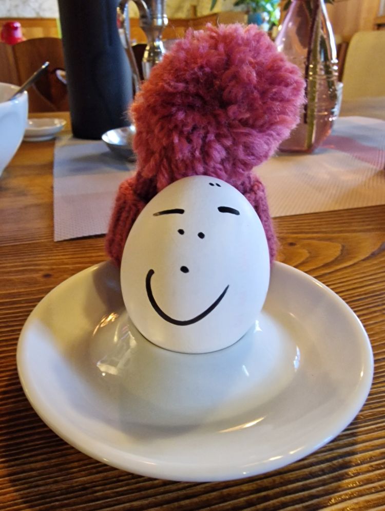
The owner is friendly. He welcomed me with a smiling breakfast egg, how kind.

For dinner, the owner serves beef olive with red cabbage and three huge dumplings. With it, I have a dry cuvée from the Elb valley. I eat on the terrace. The meal is well cooked, but I leave the third dumpling, it was too much. The owner understands me and adds: “I always serve three dumplings on the terrace, I do not want passers-by to think that I am stingy”. 

Near the station, I found the map of Geising with the main business addresses. 

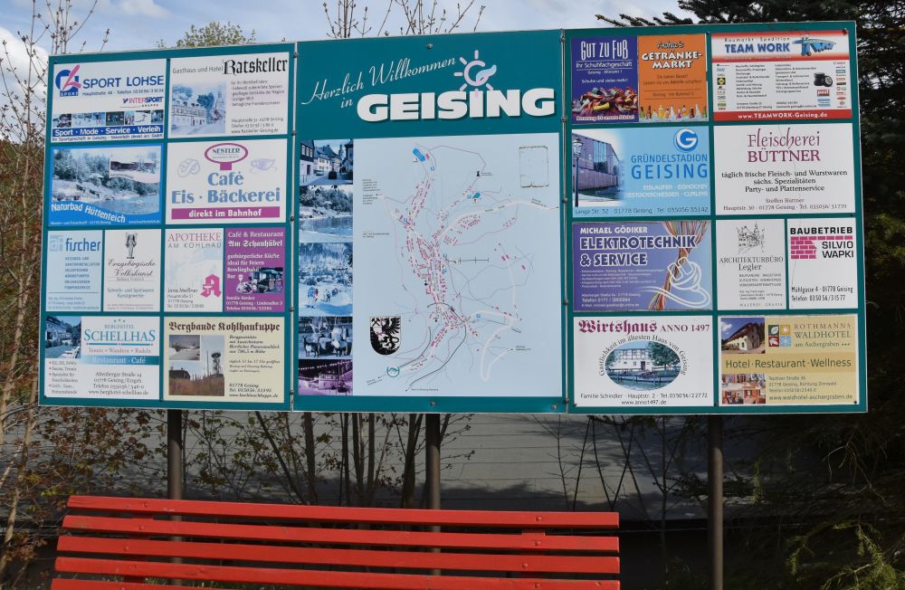
Sport Lohse was very useful. I had forgotten my thermos flask, and Sport Lohse had flasks. The lady behind the counter recommended the Sigg flask to me. Oh, yes, I know Sigg. It is a Siwss company. I bought a new black Sigg thermos flask in the middle of the Ore Mountains. I tell you, this flask is of high quality. Still after a day, my tea is warm.  

The Nestler Café is another recommendation on this panel. Nestler has his pastry shop just next to the train station.  

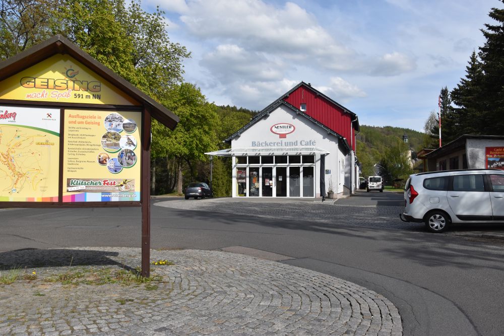
Father Nestler asked me: “What are you doing here?” I walked around the train station behind his pastry shop, where there were sheds, not really a place for tourists. He was assembling a blue plastic flower corner ordered over the Internet; the assembling did not seem to be as straightforward as expected.  He listened to me with great interest. “Oh”, he said, “we have old photos of the station, come and see us tomorrow, we are closed today.” 

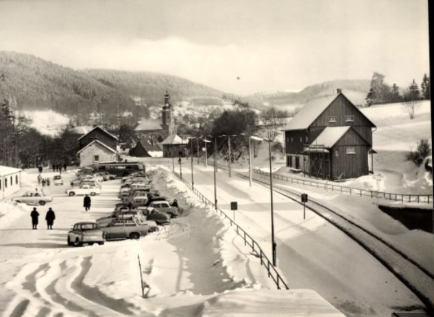
The next day, I met the junior owner of the Nestler pastry. He explained the history of the railway and the train station to me: The narrow-gauge railway was built through the Mützigtal in 1890, from Dresden to Geising. Here, the train ended in a terminus. Only in 1923, the engineers were able to extend the railway to Altenberg above Geising. The ascent was steep and could only be overcome with lighter wagons. A friend of mine told later me that for the ascent of up to 36 promille, special locomotives of type 84 were used.

In 1938, the railway was upgraded to broad gauge, and the station hall was built, as this postcard shows. The Nestler shop later settled in the small house to the left of the train station.

Source: akpool.de

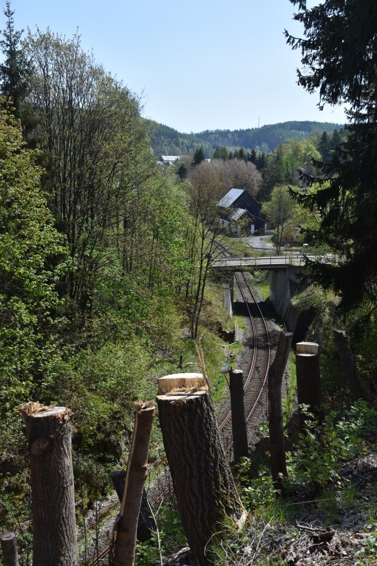
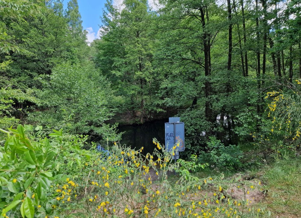
The railway coming from Dresden leads along the mountain Geisingberg. A ditch had been carved along the mountain to allow the train to arrive at Geising without steep ascent.

This is, how the rails hidden in the ditch enter Geising under the bridge (the older version of the bridge is on the painting of my grandfather).

The construction of the railway in 1890 promoted the emergence of tourism. I am sure that my grandparents took the narrow-gauge train from Dresden to Geising. 

Let us now explore the small city and the mountain Geising.


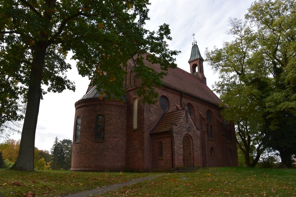
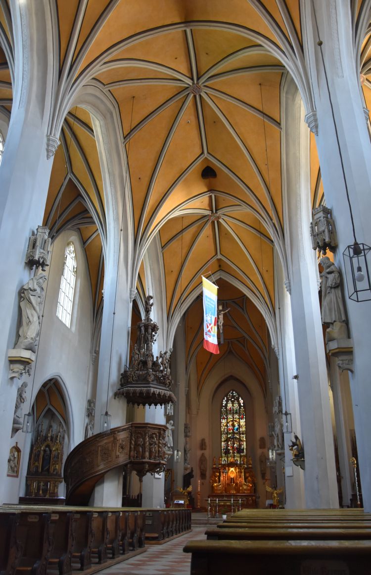
The town church of Geising

 The centre of the small city of Geising is the Lutheran town church (Stadtkirche).

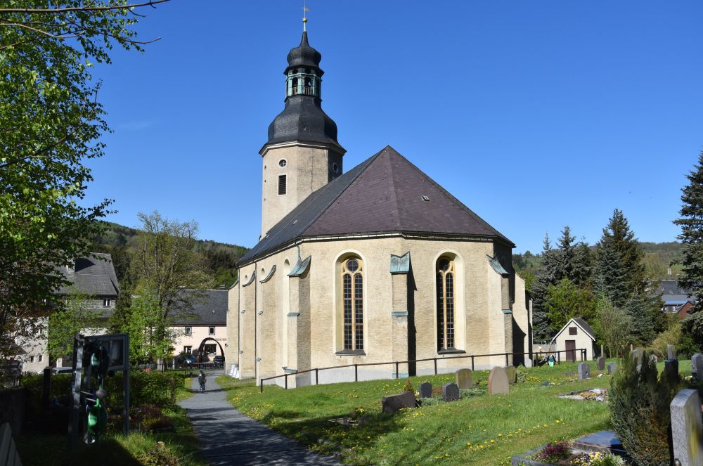
A panel explains the history of the Stadtkirche: In 1513 it was consecrated by the abbot of near Altzella. In 1539, the Reformation was introduced to Geising. In the years 1689/90, the church was enlarged.

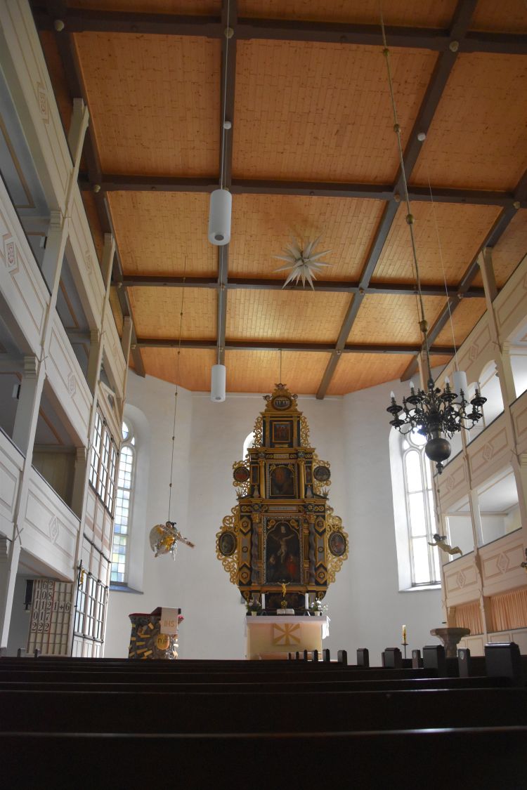
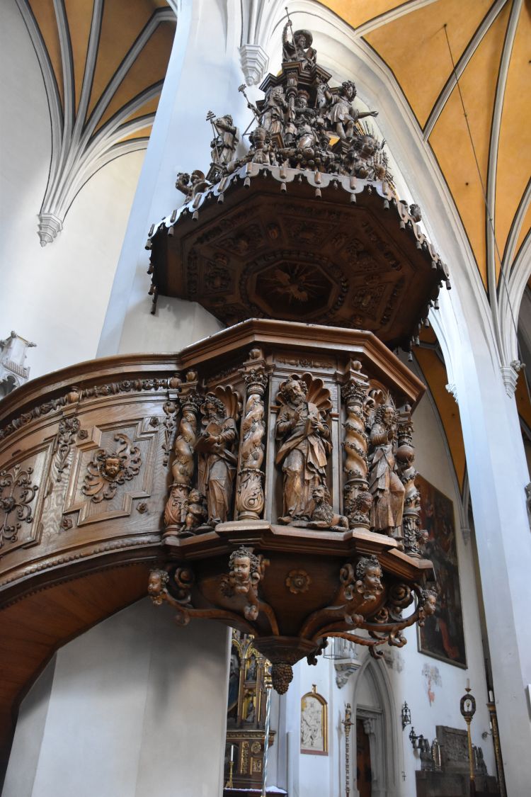
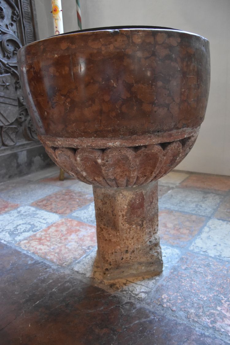
The main altar is baroque. One angel hangs above the pulpit and the second angel is above the baptismal font.


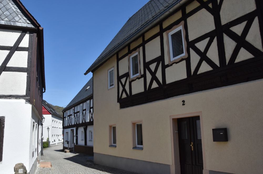
The well preserved medieval city center of Geising

Ore mining was mentioned here  already in 1371. Iron, silver, tin was explored. Two cities emerged, Altgeising to the left of the creek Heerwasser and Neugeising to the right of the creek  Both parts of Geising received the town charter in the 15th century and joined later to become Geising. The city layout has remained unchanged since the 16th century.  The center is well preserved and is under monumental protection. 

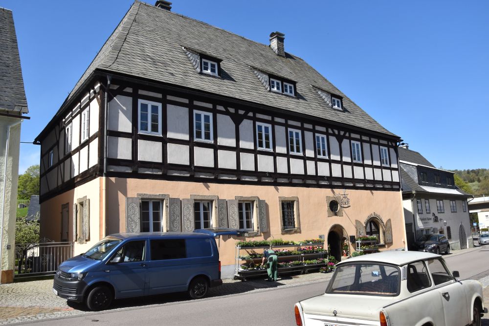
I stroll along the streets. Old half-timbered houses make the small city worth a visit. I smile, when I notice the old Trabbie car of GDR times. It stands in front of the Saitenmacherhaus (the name alludes to the producer of strings for music instruments).

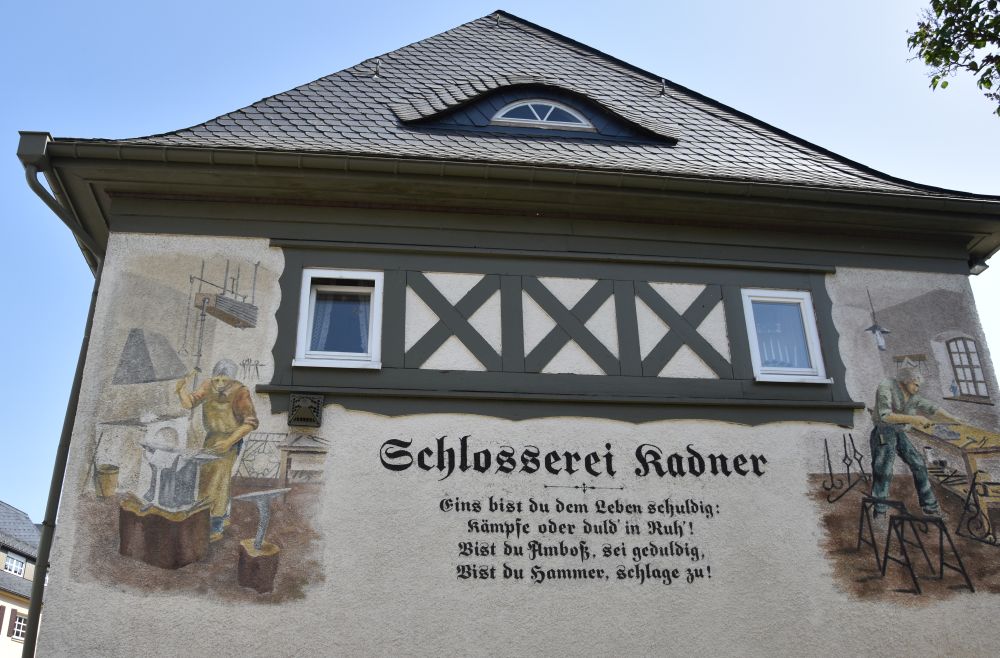
Each historical building carries its panel “Häusergeschichten” (house stories alluding to house History). Klaus Meissner has created (and signed) them based on the recordings of the chronicler Werner Stöckel. 

The “house stories” tell us that the Saitenmacher House was built in 1490, probably by Hieronimus Knorr. 1686/88, the next owner Wendisch enlarged it. Later it was the workshop of tinsmith Schütze, followed by four generations of the family Zimmerhäckel, also tinsmiths. After 1907, the house was owned by Mr Saitenmacher who gave the name to the “Saitenmacher house”. Mr Saitenmacher produced cartwrights, among other things, sledges. After 1945, the family Schlatter continued to work as cartwrights.  Now, the family Kadner runs a flower shop. What a long history. Owning a house is only temporary; someone else will take over later.

Kadner seems to be a common name here. Also the locksmith is called Kadner. Various houses are decorated with frescoes,

It is a charming little city. I follow the narrow streets to reach the train station once more.


Exploring the mountain Geisingberg and the geology of the place

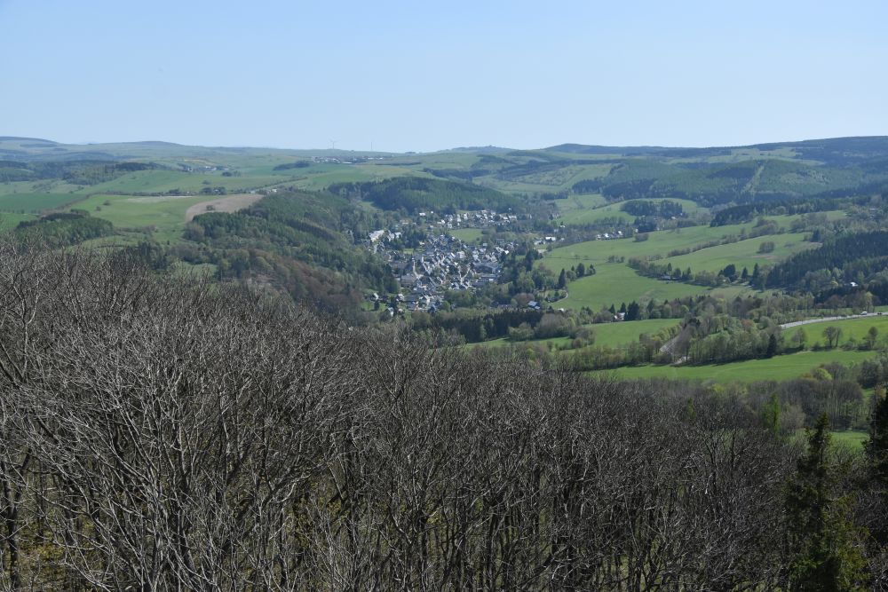
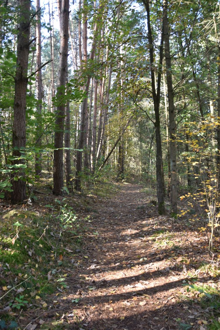
From the train station, I start my ascent to the mountain Geisingberg. I look back to Geising and the mountain Hutberg above it.

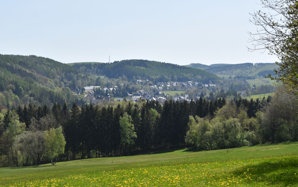
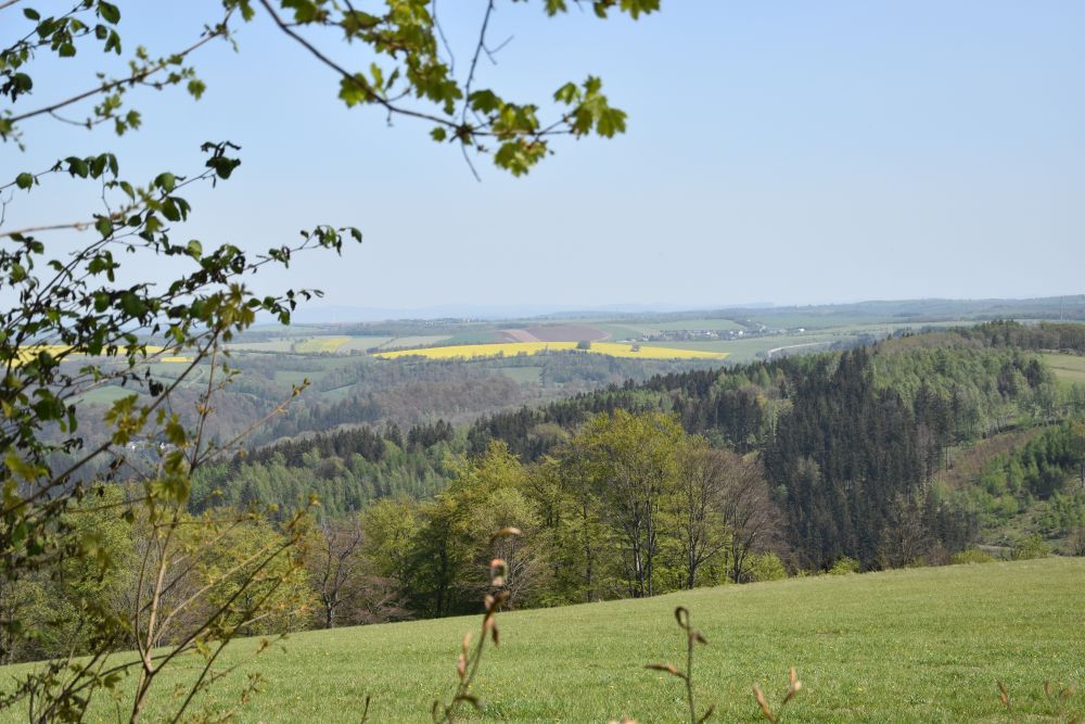
Now I am in the forest and look north, where the Ore Mountains level out towards Dresden.

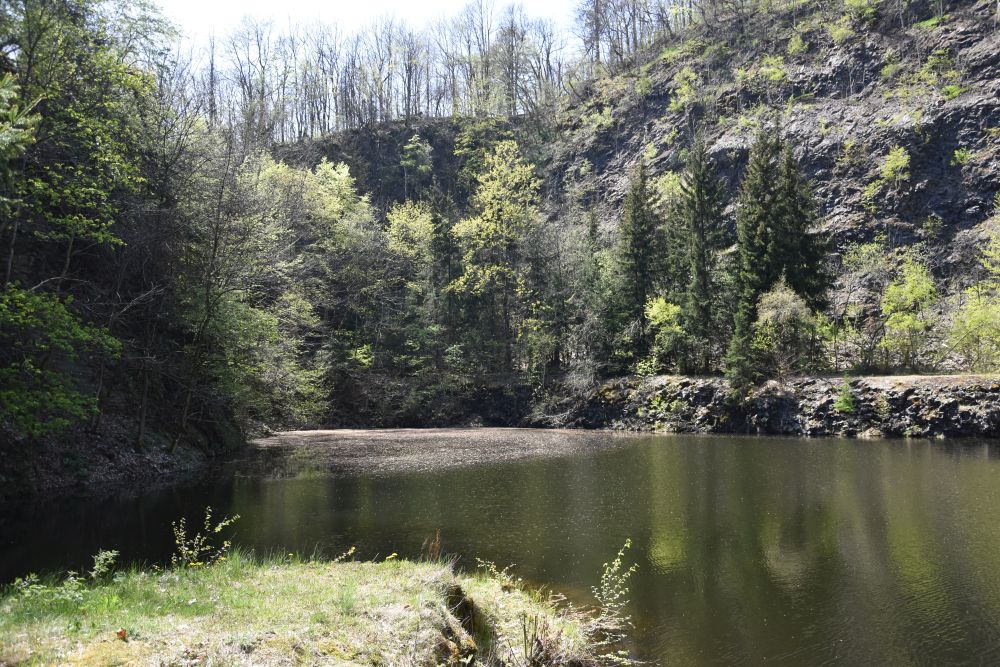
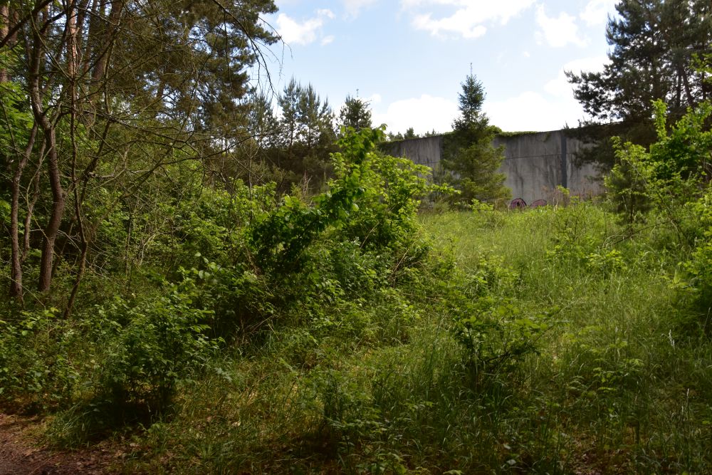
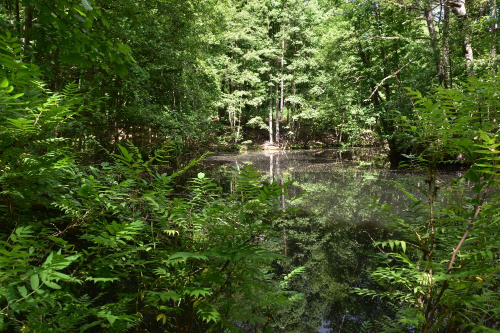
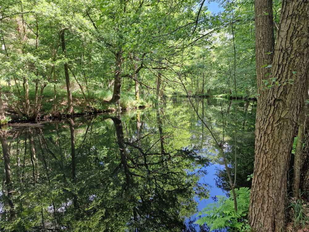
The mountain Geisingberg consists of basalt (Peter Rothe, p. 98). In the beginning of the 20th century, mining basalt started. It was halted in the 1930’s, because the citizens feared that their mountain would totally disappear. The former quarry is now partially filled with water.

On the top of the mountain Geisingberg, I pay one Euro to climb the Louise tower  and look down to Geising. 

I stand on the tower platform with two muscular men, between 30 and 40 years old. They share their views with me. I wish that the integration of the two parts of Germany would have been smoother.

Walking back down, Geising and its church come closer again. 


Friendly and welcoming citizens at the Maibaum Aufrichte (setting up the may pole)

In the late afternoon, I attend the set-up of the Maibaum (may pole) above the city. 

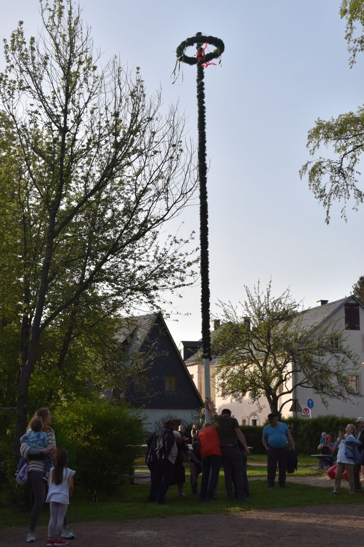
While I am eating my pork skewer, the citizens ask me to join them at their table. Soon I sit amidst a group of retired teachers and their pupils, some of them have become teachers now. They wanted to know, whether I have solved all the puzzles about my grandfather. Furthermore, they tell me that I should contact the city historian that has created all he house story panels to learn more about the history of Geising.

With the historian, I make contact later. I might return to Geising to meet him and to find out more about Heribert Fischer-Geising or Ewald Schönberg, the painters that are also related to Geising.


Thank you again

Thank you again, my grandparents, you have taken me to another wonderful corner of Germany that I would have never explored without your direction. My heart is filled with new impressions. I continue my way to Dresden and to Berlin. 


Sources:


Wasserburg am Inn – looking for two more paintings of Hermann Radzyk

It is September 2024. After having found two paintings of my grandfather at Neuburg am Inn, I am exploring two more of his works painted at Wasserburg am Inn, about 60km east of Munich. 

The first painting of Hermann Radzyk is owned by me, it has no title, no date and no signature. Initially, I assumed that it has been painted in Dalmatia.

The second painting I received from the gallery Dannenberg (Berlin) in spring 2024: “Alte Stadt am Flusslauf” (old city on the river), signed and dated to 1931. The Dannenberg painting clearly shows the same church and fortress as my painting above. 

Googling, I looked for the old city with the river and found it: Wasserburg am Inn. Hence both paintings are from Wasserburg am Inn. Probably my painting was also created in 1931. Perhaps, this painting was at the Great Exhibition of Berlin of 1933, with the title “Wasserburg am Inn” (number 309). 

Now, early in September 2024, I have booked a room in the friendly hotel Huberwirt am Kellerberg above Wasserburg to look for the locations of the easel.

Easy to find the location of the first painting: The easel stood south of the city and across the Inn on the Uferweg (riverside path). The water front line has not changed much: The balconies and the colours of the houses are largely the same.

This rock looks like a convenient place to put down an easel; perhaps my grandfather’s easel was here.

My grandfather painted the second view from the path leading up to the Kellerberg, but trees hide the view now. This was the best approximation that I could find. I am little too low and a little too much to the left. The house with the chimneys does no longer exist.

The popular “magnificent view” point on the Kellerberg provides a good impression of the city of Wasserburg surrounded by the course of the river Inn, with the church and the castle in the background that my grandfather has painted.

The river had cut a loop into the moraine landscape of Bavaria near Munich. The old city crouches on the resulting half island, 1km long and 400m wide. The fortress protects the land access that is only about 150m wide. 

On googlemaps, I have marked the positions of my grandfather’s easel, the first one across the river Inn (“river front painting”) and the second one on the path to the Kellerberg (“overview painting”).

Other painters have liked the river front view as well. For example, I found Willy Scholz on the flee market near the old city cemetery (Altstadtfriedhof).

Mission accomplished – both paintings found. Now let us look at the charming and well preserved city of Wasserburg am Inn that my grandparents took me to.


Exploring the old city center with churches and Town Hall

The medieval city center of Wasserburg has been largely preserved. It was not destroyed in the Second World War. It is a pleasure to stroll through the streets that are less crowded with tourists than other places in Germany.  I give a few insights – check the city website to see more of the medieval sights. 

After having crossed the river Inn on the bridge below the Kellerberg, I access the city from the south, using the Bridge Gate (Brucktor). 

Two guards (Scharwächter) carrying the coats of arms of Bavaria and Wasserburg protect the gate. The fresco was painted in 1890. The artist, Heinrich Georg Dendl, was born at Wasserburg in 1854.

This is the view of the gate from inside the city, from the Bridge Lane (Bruckgasse). The church to the right belongs to the hospital of the Holy Ghost (Heiliggeist Spital). The hospital was active for about 600 years, from the 14th century until 1971. 

Mary’s Square (Marienplatz) is the center of the city, with the double arched Town Hall (15th century) and the Church of Our Lady (Frauenkirche; 14th century, inside rococo from 1750).

Across the Town Hall, the building of the noble family Kern (Kernhaus) presents its late early rococo façade from the 18th century that covers two medieval houses one of them being a hotel today.

To the east of Mary’s Square, the Tränkgasse leads towards the former gate “Tränktor”. In front of the gate, horses were fed and watered, as the fresco illustrates (“tränken” means “to give water to animals”) . Horses were needed to pull ships upstream on the river Inn.

Leaving Mary’s Square to the west, I enter the Smith Lane (Schmidzeile) with more medieval houses and with this noble shop selling dirndl dresses.

On the hill, the duke’s castle marks the land access to Wasserburg. It originates from the late 11th century and was acquired by the Bavarian Wittelsbacher family in 1247. The stepped gable is late gothic.

Behind the castle hill, St. James’ Church exceeds the houses of the popular Inn water front line, as we see on the two paintings of my grandfather. The church was first mentioned in 1255 and was reconstructed after a fire in the beginning  of the 15th century. 

Gothic vaults inside.

The citizens had their reserved seats. Carrier (Spediteur) was a profession in demand at Wasserburg.

The baroque pulpit was created by the brothers Zürn around 1650.

The history of the modest baptismal font is unknown; it could be of gothic origin, but this is not proven. 

From the castle hill, there is a nice view of the roofs with the rocks of the Inn loop in the background. 

The citizens have set up cosy balconies. 

The red tower is part of the city wall.  

Under the vaults, I have delicious Bavarian dumplings.


Walking around the city on the river banks

The sculpture path leads along the Inn around the eastern edge of the Wasserburg half island. I enter the path behind the Bridge Gate. Charming small gardens and a great view of the river.  

The artists association of Wasserburg am Inn (Arbeitskreis 68) set up the sculptures along the path in the year 1988.

For 135 years up to 1988, the Inn ferry had transported people from Wasserburg across the Inn to the once popular restaurant “zum Blaufeld”. This is, what the explanatory panel says. The restaurant was on the northern side of the river loop that has no bridge. 

The convex river bank across consists of rocks covered by forest. 

In earlier times, the rocks were not covered by trees. The Inn continued eroding the convex river bank and accumulated the material in front of Wasserburg (this suburbian area is called “Gries”). The construction of hydro power plants along the Inn stopped the erosion and trees started to cover the rocks.  

Near the red tower, I enter the city again. 


Visiting the museum of the city (Museum Wasserburg)

This is the Herrengasse (“Sirs Street”) running parallel to Mary’s Square. The pink late gothic house hosts the Wasserburg museum (Museum Wasserburg).

I want to learn more about the history of the city and enter.

Two traffic routes crossed at Wasserburg: First the Inn which connected the trade between Italy, Austria and Hungary and second the salt route from Reichenhall (rich in salt) to Swabia and Franconia (lacking salt). Up to the middle of the 19th century, Wasserburg flourished. Trade and shipping created many jobs in the city, such as shipbuilders, skippers, boatmen and carriers, accessories (ropes, chains, anchors etc), loading and unloading, various craftsmen or hospitality. Wasserburg was in addition a naval port, and noble weddings and parties were celebrated on vessels here.

In the middle of the 19th century, the arrival of trains made the Inn shipping route redundant and Wasserburg lost its importance. Now out of focus, the medieval city was luckily preserved in the Second World War. 

The collection of music instruments is rich, there are virginals, fortepianos and a large collection of harps. 

Old furniture illustrates, how citizens and farmers lived in medieval times – some pieces are gothic.  

Workshop setups present old professions such as chandlers. 

I smile at these “cobble toll” regulations of 1925. A cart with a horse or any other horn cattle was charged 10 Pfennig. Smaller cattle, such as calves, foals or pigs were charged 5 Pfennig. Herds and flocks of them costed up to 4o Pfennig.

Talking about traffic regulations at Wasserburg: I noticed that this medieval city has no pedestrian areas. Cars drive in the streets and are parked all over. Traffic is, however, not abundant. The medieval city on the half island is small. I believe, the people of Wasserburg still live here and want to access their places of living also by car. Its charm has remained a secret uncovered by not too many tourists from abroad.  


What a nice city, thank you, my grandparents. The weather changes, and I say good-bye 

By his paintings, my grandfather Hermann Radzyk made me visit another beautiful place in Germany. Now I understand, what my mother (his daughter) meant in her diary in the year 1967: She described her thoughts, when she planned our car tour through Germany. She considered including Wasserburg am Inn as being worth a visit, but rejected it, because it did  not fit into the itinerary she had prepared. She must have been here with her parents in 1931, then 15 years old. Well, now, in 2024, I was at Wasserburg, and I felt close to my grandparents and their daughter – my mother. 

After so many sunny late summer days in Berlin, Poland and Slovakia, the weather changed on Monday, September 9th: Waking up in the morning, I see clouds hang in the moraines around Wasserburg. 

Summer is over, and autumn has arrived. I do not feel like travelling in the rain. These clouds look like a lot of rain for a longer period ahead. 

I decide to say good-bye to Wasserburg am Inn. I pack my car and about 500 kilometers and some six hours later, I am back at home. 

From at home, I observe heavy rainfall hit south Poland, Slovakia and east Austria – I feel sorry for the areas affected by flooding, and I cherish my good travel  memories.  


Sources:

Schloss Neuburg am Inn – on the track of two paintings by Hermann Radzyk

In September 2024, I visited Schloss Neuburg am Inn south of Passau. My grandfather Hermann Radzyk painted the castle twice about a hundred years ago.

The first picture has been signed as Hermann Radzig-Radzyk, and it is undated. The painting is in my home.

The second painting, I found in the Internet. It is signed and undated, and has been sold by the Galerie Wildner at Passau. 

Hermann Radzyk made these two paintings, when, in July 1925, he stayed in the castle; it was an artists’ hostel then.  

For the second painting, the easel stood north-east of the castle. I could reproduce the view; there are just more trees and bushes here today. 

For the first painting the easel stood south of the castle near the road. Too much forest here to reproduce the view. On my photo, I stand in the garden above the road. Only here, I could see the defensive tower. Perhaps the easel stood, where the bush below me has grown in the meantime.  

Now, let me tell you about my investigations one by one: When I started, I did not know, what castle he had painted. Once I had identified the castle, I looked for the place, where he had put down his easel and for the date, when he has painted it. I will start telling you from the end.


Investigating “when”: No date on the painting – why do I know, the painting is from 1925?

My first guess was that Hermann Radzyk had painted the castle in 1924. In the year 1967, my mother (Hermann’s daughter Marion) took me on a tour through upper Swabia and Bavaria. In her diary she wrote, she was about eight years old, when she stayed at the castle with her parents. While her father painted, she went for excursions with her mother, she added.  My mother was born in the year 1916. In 1924, she was eight years old. Hence “painted in 1924” was my first guess. 

By one year wrong. When I stayed at Neuburg, I found the guest book of the castle, and the guest book told me, the paintings are from 1925.

A friendly man parking his car next to mine gave me the hint: Ask the former Kreisheimatpfleger (the former responsible for fostering regional values). I called and met him in the evening; he brought along the guest book, where I found Hermann Radzyk’s entry not for 1924, but for 1925.

It is the fourth entry on this page: “Hermann Radzyk with wife and daughter, Charlottenburg, Waitzstrasse 2, July 25”.

At the same time, the prime minister of Bavaria, Dr. Heinrich Held, member of the Bavarian Socialist Party, stayed in the castle. Many guests were from Berlin. It was a mixture of politicians and artists. I imagine the discussions in the cosy lounge of the hostel were vivid.


Source: Photo of the castle museum “Landkreisgalerie”.

Surely, Hermann Radzyk painted the castle, when he stayed here in the year 1925. In July 1925, to be more precise. His daughter (my mother) was then 9 years old. 

Today the castle offers guest rooms in the former Mälzerei (malting plant). I rented a room here at the same castle, where my grandparents and my mother stayed almost a hundred years ago.

Only double rooms are available at the Mälzerei. I felt like a damsel – well perhaps more like the grandmother of a damsel.

The rooms of the hostel for artists, where my grandparents stayed, were located in the centre of the castle. Today, the former hostel has become the castle museum “Landkreisgalerie”. Access to the museum is via the gallery.

I imagine my grandparents with their daughter walking around the castle to look for a nice view for the paintings.


Investigating the location of the second painting that we can still “see” today

Let us recapitulate the second painting: It shows the north-east side of the castle with the east tower, the defensive tower behind it, and the main buildings with the chapel.

The castle Neuburg stands on a rock above the river Inn. On the northern side, there is a canyon. I climbed up the counter slope and looked at the castle with its entry tower (right), the east tower and, immediately behind it, the defensive tower (called Bergfried or Burgfried in German). 

From this view, Hermann Radzyk has extracted the left part with the east tower, the defensive tower closely behind it, and what looks like an oriel is the chapel.

Today, the meadow in front of the castle has mostly disappeared. The son of Lithuanian refugees, who was born in the castle, told me that, in earlier times, when the meadow still existed, it was called “Ledererwiese”, because the tanner spread his leather here to dry it in the sun. No tanner lives in the village under the castle any more, no one needs the meadow now, and the trees and bushes could grow.   

On the counter slope, I stand on this small “platform”, the easel must have been behind the bush – but there was no bush here at that time. 

I returned in the morning. The light has changed, and it is closer to the atmosphere created by Hermann Radzyk, where the morning sun illuminates the east wall of the castle above the river Inn. 

Let us look at the east wall of the castle from the other side of the river  Inn, from Wernstein in Austria. We can see the centre castle buildings.  This is, where the artists stayed. From the windows and the terrace, they had a wonderful view of the river Inn and the hills of Austria. Now, the museum is to the right of the chapel and the conference rooms are to the left the chapel.

A side remark: My mother was a geologist. In her travel diary of 1967, she described that the river Inn cuts through the rocks of the Bavarian Forest (Bayerischer Wald) and enters the Bohemian Mass (Böhmische Masse), just before joining the Danube at Passau. The canyon is called “Vornbacher Enge”.


Investigating the location of the first painting: Trees hide the view today

Let us recall the view from the south, as captured by my grand-father in the “first” painting.

My mother wrote in her travel diary from 1967 that she immediately recognized the castle, when she drove our car from the south (from Neuhaus am Inn) to Neuburg. She was impressed, how well her father had captured the view and how well he conveyed the impression of the castle. It was engraved in her memory even more than forty years later. We went for a short walk through the castle, and she noticed, it was still a hostel then.

In the year 1957, Karlheinz Biederbick, painted a similar view; his easel was a little lower and more to the right than the easel of my grandfather. Biederbick’s easel stood next to the bus station on the side of the road coming from Neuhaus. This must have been the place, where my mother, 10 years later, recognized the castle, when she drove from Neuhaus to Neuburg in 1967.

I received the photo of Biederbick’s painting from the son of German refugees from Lithuania that were placed in the castle after 1945. He was born in the castle and grew up here. It was still a hostel for artists then, and he grew up with the artists, among them Biederbick. He knew exactly, where the easel was, because as a boy he sat next to the artist.

BUT, when I now, in 2024, drove my car from Neuhaus to Neuburg, I could not see the castle. It was behind trees. I later took this photo from about the place, where Biederbick had put down his easel, next to the bus station. There are some gaps between the trees, where it is possible to get an idea of the defensive tower behind the trees. 

Only from the garden of Schärdingerstrasse 28 above the road and above the bus station, I could see the defensive tower. However, the easel of my grandfather  stood lower and more to the right. Perhaps where the  bush is now. My grandfather and Biederbick could no longer make their paintings today.

The owner of the house 28 was friendly and let me enter his garden.

I met many hospitable citizens at the small village Neuburg grouped around its castle above the Inn. With the son of the refugees (about my age), I spent a warm summer evening in his garden, just under the castle. He lives in a beautifully restored house full of treasures telling stories about the castle and the area around it as well as about his life as a showman with a doctorate in mathematics. It is a welcoming place for a vacation and a great starting point to explore the area at the border between Bavaria and Austria.


Preliminary investigations to identify the castle that Hermann Radzyk had painted 

When three years ago, I started the research about my grandfather Hermann Radzyk, I had no idea, which castle he had painted. 

I first suspected, the castle was at Silesia. Later I found the castle called Schloss Neuburg an der Kammel in Swabia, but it had only one tower. Burg Neuberg in Austria looked also similar, but the defensive tower had three and not two windows. I knew in the meantime that Hermann Radzyk painted TWO windows, when there WERE TWO windows. Impossible that Burg Neuberg was his castle.

Finally, I thought that perhaps it is not a coincidence that the gallery Windler at Passau has this painting on their website. I looked for castles around Passau, and found Schloss Neuburg am Inn.

This is almost precisely the view of the Wildner painting. The defensive tower in the background has two windows, like on the painting of my grandfather. 

I found a different photo of Schloss Neuburg. The “broken” wall looks very similar to the painting that is owned by me.

Source: Landkreis.de

There is just one mismatch: The defensive tower in the middle does not carry a lantern. Perhaps, the lantern has been removed later?

I looked for old postcards. And I found the lantern on the defensive tower. 

Source: akpool.de

Now, I was sure that Hermann Radzyk had painted Schloss Neuburg am Inn near Passau.

When, in September 2024, I spent the warm summer evening with the son of the Lithuanian-German refugee, he told me, that the lantern contained a bell and that it was only removed in the 1980’s. This is why, the painting of Biederbick from 1957 still shows the lantern. 

Only in summer 2024, I discovered my mother’s diary about our tour in 1967. Only then I understood that I had already been at Schloss Neuburg in 1967, when I was 16 years old, almost sixty years ago. But at that time, I was not aware of the castle painting (it did not hang in my parental home), and I forgot our short visit at the castle. The Baroque city of Schärding and Passau with the different colours of the Danube and the Inn stayed in my mind, but not the castle.

After all my investigations, I added Neuburg to my travel agenda… and arrived here in September 2024 staying overnight at the same castle as my grandparents.


Orientation – where are we?

Schloss Neuburg am Inn is in Germany, above the river Inn. The Inn marks the border between Germany and Austria. Wernstein is in Austria and so is Schärding. Neuhaus, Neuburg and Passau are in Germany. 

The easel of the first painting was located near the road coming from Neuhaus (easel “south”). The easel for the second painting was on the counter slope across the canyon north of Schloss Neuburg (easel “north”).

At the entry gate, I found this overview of the castle. 


Let us stroll around the castle Schloss Neuburg

Immediately near the castle entry is the paradise garden.

From the fountain in the paradise garden, I am looking towards the entry gate. The Mälzerei is located to the left side of the gate tower.

Entering the gate tower, we reach a bridge that leads to the main tower, the Bergfried in German. It was decorated with the small lantern until the 1980’s.

I visit the museum; it is where the guest rooms of the hostel were before. The cashier takes me to the small chapel behind the museum.

Continuing from the chapel, I reach the painted rooms that now can be rented for events or conferences.  

From here, the views of the Inn and Wernstein in Austria are superb.

Strolling around the castle, I find this fairy tale lake. The artists’ path starts here leading down to the river Inn. 

The Habsburgian Emperor Leopold I retreated to this castle in 1676, when the Turks became a danger for Vienna (they sieged Vienna then in 1683). At Neuburg, he married his third wife, the Palatine princess Eleonore. It was safer here than at Vienna.

The wooden round panel decorated my room at the guest house Mälzerei, and the Lithuanian-German had another copy of this panel in his house. He made me aware of emperor Leopold.


Good-bye Neuburg

Good-bye Neuburg, I have spent two wonderful days here, I have solved another piece of my puzzle: I found out when and where my grandfather has made the two castle paintings. I have met many friendly people that helped me solve my puzzle here. And I have discovered another place worth visiting, the castle Neuburg am Inn and its surroundings at the border between Bavaria and Austria, with Wernstein, where Alfred Kubin lived and with Schärding that prepared the baroque city centre for the food festival “Schlemmerfest”.


The next piece of my puzzle is waiting for me at Wasserburg am Inn, where my grandfather painted six years later, in the year 1931. 


The third altar of Riemenschneider in the Tauber valley – at Creglingen

In August 2024, I follow the call of my grandfather, the artist Hermann Radzyk, and explore to the Taubertal. This morning, I have just visited the Celtic oppidum, and now, after a few more kilometers, I stand in front of the Herrgottskirche (Lord’s Church) at Creglingen. Here, I am looking for the third altar of Tilmann Riemenschneider that can be found in the Taubertal.

It is a miracle that makes this church special. A farmer had found the untouched piece of sacramental bread in the year 1334. Exactly where the bread was found, the local earl decided to build the church. It was inaugurated in 1396, with an altar at the exact location, where the bread had been found. A window allowed to see the bread and the earth.  The church and the altar became a pilgrimage site. This is, what I read in the brochure of the church (p. 1). In 1530, the margrave of Brandenburg-Ansbach adopted the protestant doctrine of Martin Luther and introduced it to his territory. As a consequence, the pilgrimage came to a standstill.

I walk around the church. The graceful tower outside is called “Tetzel tower”. However, it is unlikely that Tetzel stood on this pulpit to promote buying indulgence (forgiveness for sins), a commerce that Martin Luther was fighting against. Instead, the pulpit was probably used by the local priest on special occasions. 

Before the reformation in 1530, the church made good money due to the pilgrimage. At the end of the 15th century, they decided to acquire several altars for the church. Today, four spectacular altars from around 1500 decorate the church.

The altar of Tilman Riemenschneider attracts the most attention. More dignity was required for the place, where the sacramental bread had been found. The stone altar with the window disclosing the bread was no longer good enough. Between 1505 and 1520, Riemenschneider and his workshop fabricated the magnificent altar of Virgin Mary (Marienaltar). It is 9m20 high and 3.68m wide. The figures are made from lime wood (brochure, p. 21).

I am impressed. The altar of Mary stands in the middle of the nave, in front of the window behind it. I read that this window illuminates Mary from behind exactly on August 15th according to the Julian calendar, then the day of Mary’s Assumption. Today, the light of the window falls on Mary on August 25th, the Gregorian calendar reform of 1582 has shifted the date. 

Riemenschneider based his work on some etchings of Martin Schongauer and another master. Mary’s Assumption scene is in the middle, Angels carry Mary to heaven, the apostles are grouped around her, and the gap between the apostles makes it clear that Mary has left the ground. Around Mary’s Assumption, there are four scenes from the life of Mary: Annunciation by archangel Gabriel, Visitation (Mary – pregnant – meets Elisabeth, then also pregnant with John the Baptist), the birth of Christ in the stable and the Circumcision of Christ. 

Above, there are the Coronation of Mary and Christ as the Man of Sorrows. 

In the predella, we see the three Magi to the left… 

… and Jesus teaching at the school of Zachaeus to the right.

In the middle, there are two angels – it is assumed that the monstrance with the sacramental bread stood between them, but it is lost. Luckily we have not lost more of this altar. 

Soon after Riemenschneider’s altar had been installed in the church, the reformation took place. The reformers wanted to destroy the altars in the church. The priests and the citizens of Creglingen closed Mary’s altar and hid it away behind a board wall. The place became a shed for wreaths, and soon the altar was forgotten. About 300 hundred years later, probably after 1800, the altar was opened up again. Only, because there is a portrait of Riemenschneider in the predella, we know that the altar has been created by him. Fortunately, he has left his signature. And because on the “old” Assumption day, the light falls precisely on to Mary from the rose window behind her, it is clear that Riemenschneider has designed it for this church. What a story! 

I spend a long time in front of Riemenschneider’s altar studying the vivid expressions in the faces, the fall of the folds and the shadowing. Riemenschneider WAS a master. 

There are more wonderful altars in this church, all made around 1500 to support the pilgrimage still active then. 

The main altar stands in the choir. The artists are not known. The altar shows the Passion of Jesus with the crucifixion in the middle, two events before it (Gethsemane and Carrying of the Cross) to the left and two events after it (Entombment and Resurrection) to the right. 

The northern side altar illustrates the engagement of Mary and Joseph (the Virgin Mary is already pregnant), the birth of Jesus and the scene with the Three Magi in the middle. In the predella are two beautiful paintings, to the left the evangelist Markus, to the right Matthew. Matthew prays intensely looking to heaven, an angel watches him. The liveliness reminds of Renaissance paintings. 

The southern altar shows various Saints and martyrs. In the predella, I recognize Moses on the side wing next to the Last Supper, . 

I do not understand, why Moses has horns, it may be something like a gloriole, but this is, how I always can identify him. The scene shows the wonder of the bread in the desert. 

Before leaving the church, I greet Christopher – the fresco is from the beginning of 16th century. 

He is the patron saint of the travellers and the means of transport, and I am a traveller right now. 

I leave the church. On the one side of the entrance are the wrangler (in German: Streithähne which translates literally to “quarrelling cocks”; the two cocks are the illustration of the wranglers).

On the other side is the “sceptic” – the man robbing his beard seems to be in doubt, he is sceptical.

The wranglers and the sceptics have to remain outside the church. What a nice symbol.

I leave the wonderful Taubertal now and drive north towards Berlin.


Sources:

  • Sabine Kutterolf-Ammon, “Die Herrgottskirche zu Creglingen”, Kunstschätzeverlag, Gerchsheim 2016. (Brochure)

The Celtic oppidum in the Taubertal

In August 2024, the paintings of my grandfather Hermann Radzyk had motivated me to visit the Taubertal. I searched and found the easel locations at Rothenburg and Detwang. Now, I explore more of the Tauber valley. My first target is the Celtic oppidum Finsterlohr-Burgstall.

In the 2nd/1st century before Christ, the Celts had built an oppidum on a plateau above the Tauber valley. An educational trail of 2.5km was inaugurated by the association Kelten-Creglingen-Finsterlohr at Easter 2023. The trail is marked by the green coloured line on the panel ; it covers a small part of the former oppidum.

I am curious. With my car, I drive north from Rothenburg ob der Tauber following the road along the Tauber river. 

The river is cut deeply into the German plateau landscape. 

The oppidum is on the plateau. From the Tauber valley, a narrow steep road leads uphill, and I get stuck; a shepherd with his herd enters the narrow road from the right and heads down. I stop, another car coming down stops as well, and we wait. The sheep pass by my car on the steep embankment of the road, it is an enormously large herd. 


I feel sorry for the sheep. When the last sheep has past, the car coming down and me going up miraculously manage to cross each other. I drive up, reach the plateau and park my car at the start of the educational trail of the oppidum. I am the only car here and the only visitor. It is drizzling.

At the entrance, this panel explains to me, what I am going to see. 

On the shell limestone plateau, the Celts had selected the location for their oppidum carefully. It was well protected by the Tauber valley and two other smaller canyons. Only 1.2km of the oppidum, open towards the plateau,  would have needed protection. Nevertheless, the Celts protected the whole oppidum by a wall. Most of it has disappeared today. The main entrance to the oppidum was in the north above the Tauber valley. Excavations had uncovered the remains of the pincer gate (the panel shows the former passageway).  

I get started. Behind the picnic table, the models of a Celtic house and a Celtic oven mark the first station on the trail. The panel next to it explains it all.

The Celts used loam to build their houses. Loam, a mixture of clay, sand and silt, is still in use today to build houses. For weather protection, the Celts painted the outside walls with white lime. 

Inside, there was a fireplace. The smoke waterproofed the roof and chased insects. 13 to 15 persons lived in such a house; with limited space and smoke, life must have been pretty uncomfortable.  

In the loam oven, the Celts baked bread at a temperature of 200 to 250 degrees. When the bread was done, they dried fruit in it, while it was cooling down. Rather sustainable production methods, we would say today.

The trail is well marked. I continue following the signs.

First, I walk “through the former village”. This is the view of the plateau looking south. 

In the distance, south, I can see Rothenburg ob der Tauber. 

I reach the earth rampart at station 2. The post-slot-wall (Pfostenschlitzmauer) has been reconstructed; now I can see the upper wooden part above the earth rampart.

From the other side, it becomes clear that the wall was a dry masonry construction with oak beams (every 2.2 meters) and, at the back, the wall was fortified by the earth rampart. Overall, the wall was six meters high. 

The wall went from south east to north east, the ditch indicates, where it was.

From here, the educational trail follows the former wall taking me north west and towards the Tauber valley. 

I reach the edge of the Tauber valley and the remains of the former pincer gate (Zangentor). In front of the gate, the last 30m of the exterior road were lined with two lateral walls (the “pincers”). The resulting passageway (Torgasse) lead to the wooden gate. I read the panel, and I admit, I could not identify the remains of the gate; you can see the remains of the passageway on the first information panel of the trail (above).

I walk along the edge of the Tauber valley, until the trail turns right and leads me back across the former oppidum to the starting point. 

While walking, I studied the panels informing me about the Celts. Here are some of my learnings.

The oppidum comprised about 112 hectares surrounded by the ring wall of 5.7km. The history of this oppidum is not known; it is not clear, how it was used by the Celts, as a permanent place of residence or as a shelter. The oppidum could have been part of the network of Celtic oppida, some of them covered more than 100 square kilometres. The oppida provided protection for people, their animals, the pastures and the fields. In addition, they were trade centres. 

The Celts were organized in tribes, not as nations. The Celtic society flourished in the 6th/5th century before Christ. They traded with the Mediterranean region, as archaeological finds of amphorae or tableware prove. They replaced their barter system with a money system; they minted their own silver and gold coins. Later, in medieval times, people found  pieces of gold in the fields, mostly after heavy rainfall. They believed that the pieces of gold had fallen down from heaven and that they would help to cure fever or pain.  

The Celts started to write adopting the alphabets of other peoples, e.g. the Greeks. However, writing was reserved to ordinary purposes, while the druids continued transmitting their knowledge orally. 

The Greek invented the name “Celts”. For instance Herodotus wrote about them in 450 before Christ. He was aware of the Galatians in Anatolia that were also a Celtic tribe. By the way, the Celts had also settled on the Cathedral hill of my home city Basel. Above the Rhine river,  the remains of a similar Celtic wall have been excavated, and the explanatory panels show the same post-slot-wall construction. 

The Celtic culture disappeared, when the Romans came. The Celts were romanized. I believe, they must have preferred the Roman way of living, as it was more comfortable (heating, water provision, baths, theatre, more effective agriculture and animal raising…).

I finish my tour. I feel wet, it is drizzling. The last information panel stands near the “Old  Lake”, rather a swamp than a pond. Looking at it, I feel even wetter. 

With this swampy pond, I say good-bye to the Celts and their oppidum and continue my way to Creglingen, where another altar of Til Riemenschneider is waiting for me.  

Sources:

Strolling through Rothenburg, where Hermann Radzyk painted the Plönlein

Rothenburg’s Plönlein, painted by Hermann Radzyk in 1942, looks different now – why?

In 1942, my grandfather painted the Plönlein of Rothenburg ob der Tauber. It is the small half-timbered house with the curved beams. 

Look at my photo of the Plönlein. The architecture is different, the beams have been straightened. 

What has happened? Has the Plönlein been destroyed in World War II?

In World War II, 40% of the city of Rothenburg were destroyed. On Holy Saturday, 31st of March 1945, an American squadron set out to release their bombs near Rothenburg, but failed, because their target was in the fog. Fully loaded they were not able to land, and, on the way back, they released their bombs above Rothenburg. Bravely, the citizens of Rothenburg reconstructed their city in the medieval style (see “Rothenburg-unterm-hakenkreuz”).

I always suspected, also the Plönlein had been destroyed by the bomb attacks, but no, it was renovated after the war. I learnt that in October 2024, when I had breakfast in the Hotel Uhl next to the Plönlein. The owner’s father said that the Plönlein had not been affected by the bombs, though the house right across the street was damaged. The Plönlein was renovated in the 1950’s or 60’s, because the old beams were rotten. And now, the beams of the Plönlein are no longer curved, but straight. The tourists continue to like it.


The Plönlein is the tourists’ favourite, and Plönlein souvenirs are in high demand

The Plönlein is THE attraction of Rothenburg. The Schmiedgasse is crowded with tourists.  What would my grandfather say?

This Japanese couple dressed as Bavarians in dirndl and leather shorts (called “Krachlederne”) is getting ready to make a selfie in front of the Plönlein. They enjoy it, they laugh, and I smile with them. 

Next to the Plönlein, the small restaurant Peking caters for Chinese tourists advertising their meals in Chinese.

Souvenirs of the Plönlein are in high demand. They appear in the souvenir shops on curtains, …

… beer tankards, … 

… ceramic tiles and plates, …. 

… bags, T-shirts, key rings, fridge magnets, snow globes, framed photos or paintings … they are sold as small model houses…  no limits to the phantasy and mostly at the brink of kitsch.


The market square: The “twin townhall” and medieval houses

The centre of the city is the market square with the “twin townhall”. The white part with the tower is Gothic (built 1200-1400), the ochre part is Renaissance (16th century, constructed after the great city fire of 1501). 

The Renaissance staircase disappears behind the gallery that has been added in the late 17th century.

I climbed the Gothic white townhall tower. First I walked up comfortably in the Renaissance staircase. Next, in the old tower, the stairs became steeper and steeeper, and on top, I had to do almost rock climbing to lift myself from the last step on to the balcony platform. I took no photo, I stood in the mist, it was a rainy afternoon.

Across the townhall, these beautiful half-timbered houses line the market square; in the house labelled “Marien-Apotheke”, emperor Maximilian I was a prominent guest in 1513.  

The other building is called Meat- and Dance-House. The Künstlerbund, founded in 1923, makes exhibitions here and, according to their website, they are open every day after 13.00. I was curious, but the door was closed. I could not find out, why. The Künstlerbund seems to be a secret association. 

In front of these two half-timbered buildings, a fountain had been installed in 1446. In 1608, it had been replaced by the Renaissance fountain that we see today. Saint George fights the dragon.

The market square is lined with medieval houses, carefully rebuilt after the bomb attack of 1945. The building with the historical clocks is the Ratstrinkstube (something like an inn reserved for the councilmen). Field marshall Jean Tilly and old mayor Georg Nusch appear every full hour in the windows besides the clock. They illustrate, how, in the 30 years’ war,  the old mayor saved the city by drinking a tankard of 3.25l of Franconian wine in one go.

Right below and behind me is the Renaissance Baumeisterhaus, the house of the main mason of Rothenburg. He built his house with the sculptures in 1596. 

Impressive medieval marketing.

Inside I find a restaurant in a court,  a wonderful atmosphere. However, the restaurant is good for people that like a lot of meat with dumplings, but hate vegetables. I found better restaurants at Rothenburg, such as the Butz or the Glocke.


The Saint James church with the Heiligkreuz altar of Riemenschneider 

The Gothic St. James church, built between 1311 and 1484, became a Lutheran church, when Rothenburg joined the reformation in 1544.

A modern friendly Saint James with a smile on his lips invites the pilgrims to enter the church (sculptor: Steinacker, 2002; see Gussmann).

There are also some tourists who follow his invitation – like me. Inside the Gothic vaults seem to rise up to heaven.

In 1499 to 1505, Til Riemenschneider created the Heilig-Blut-Altar (Holy-Blood-Altar) for the west choir that crosses the Klingengasse. Riemenschneider was asked to build the altar for the relic of the Holy Blood; he placed the relic in the gilded cross of 1270; it is held by two angels. Below and in the centre, there are the Last Supper, the Garden Gethsemane and Jesus entering Jerusalem. The altar with its relic became an important pilgrimage site. It is unique that a protestant church contains a relic for the Catholics, it is a sign of reconciliation.

In the scene of the Last Super, Judas is in the centre, not Jesus. Jesus passes Judas the bread. It is the moment, where Jesus says: “One of you shall betray me”. I see the shock in the faces of the disciples. For instance, to the right, two of them seem to be debating: “No, it will not be me, I will not betray Jesus…”. However, the pastor Oliver Gussmann says that the disciples seem to take no interest in the scene with Judas and Jesus (https://youtu.be/An5XAw1fr78). He would perhaps say, the two debating just continue being focused on their intense debate. The unusual and vivid setting of the Last Supper is fascinating, the expressive faces of the disciples call our imagination and evoke our own interpretation. Riemenschneider had carved the figures out of limewood.

 –

In the eastern choir, there is another gem: Friedrich Herlin was the construction manager of the “Twelve Apostles’ Altar” (Zwölfbotenaltar, 1466). It has its name from the Predella, where Jesus appears with the twelve apostles. 

In the middle, we see the crucifixion scene with Maria, James and Elisabeth von Thüringen to the left and the disciple John, a bishop (perhaps Leonhard) and Antonius with his bell to the right (Rothenburg brochure, p. 22 and video of Gussmann). 

Herlin himself made the paintings on the side wings and the Predella. Some of Herlin’s figures wear glasses. When Herlin became older, he had problems to see the details; wearing glasses he could read and paint again (Gussmann). Herlin was so impressed that he gave glasses to some of the figures on the altar, for instance to the circumciser in the Circumcision scene.

Also Petrus in the Predella wears glasses; he is an elderly man and needs them for reading. Never before have I seen people wth glasses on a medieval altar.

The backside of the altar hides another amazing painting: The dead body of James is carried into Rothenburg ob der Tauber; on the market place of 1466 both parts of the “twin” townhall were still of Gothic style; this happened before the great fire of 1501.

Of course, St. James entered Santiago de Compostella, but Herlin had never been there. The city he could paint best was Rothenburg.

The altar of the Coronation of the Virgin is attributed to the Riemenschneider school.  

The Ludwig-von-Toulouse altar is from 1490; it is an early work of Til Riemenschneider. Louis de Toulouse was the bishop of Toulouse around 1300.

The windows in the main choir (from the late 14th) give a solemn atmosphere to the church. Gussmann explains them beautifully in his video. They were saved from the bomb attacks of 31st of March 1945, because the citizens had taken them off the church and had transferred them to a basement that withstood the bombs. Also the other treasures of this church survived the bombing there. 

I say good-bye to Christoph carrying Jesus across the river… 

… and to St. James (now in Gothic style), …

… and I continue strolling through the city.


Some impressions from the streets with its medieval atmosphere

Descent is only allowed to carts carrying persons (Personenfuhrwerk). Pedestrians may also be allowed. 

This oriel is called “Feuerleinserker” (oriel of the little fire), the house is from around 1600.

The Herrngasse was the noble address, where the patricians of the city once lived. Now it is lined with hotels, restaurants and shops, amongst them the hotel Gothic House.

The neighbour, the Hornburg-Haus, is half-timbered. Some beams are from the year 1477. The house is in search of new shop tenants.

Around the corner, in the Klosterstüble, I had a delicious Bavarian-Franconian dinner with dumplings. 

The Landsknechtstübchen is beautifully adorned with geraniums (A “Landsknecht” is a man at arms).

Across the street, the family owned restaurant Ochsen looks inviting. 

When strolling through the city, two more churches invited me for a visit. First the modest Franciscan church with the rood screen.

In the choir and behind the beautiful baptismal fountain, there is another small altar of Til Riemenschneidre showing the history of Franciscus.

Second, I enter the Gothic Church of Saint Wolfgang, the patron of the shepherds. It has been built into the city wall. 

Three wonderful altars are inside. 

From the choir, you can enter the wall and walk through a tunnel  that ends up on the other side of the nave. Amazing.


The city wall and the Burggarten

The city wall with the gates still today surrounds Rothenburg.

Walking along the moat west of the city centre… 

…  takes me to the Burgtor, …

… where the Burggarten starts. Here, the Hohenstaufen had built their castle in the 12th century, after the dukes of Rothenburg had died out. The Staufen castle has disappeaered. Only a small chapel is left.

The Burggarten is well kept and romantic.

From the Burggarten, the southern part of the city line appears above the Tauber valley. 

One morning, I did the wall walk all around the city. Homely corners…   

… and roof “landscapes” all along the walk.


More painters felt attracted by Rothenburg, as the museum in the former Dominican monastery tells us

The museum in the former monastery of Dominican nuns lays out the history of Rothenburg ob der Tauber. 

 In the 19th century, various journals praise Rothenburg to be the ideal medieval city with its picturesque architecture. The message is heard in Germany and  Europe. Painters from Germany, the Netherlands and England come to Rothenburg, and one department of the museum is dedicated to some of these painters. Hermann Radzyk was not the only painter that felt attracted by Rothenburg.

Most exhibits in the museum are paintings of Wilhelm Schacht (1872-1951). He painted the old brigde at Detwang (left), like my grandfather. On the second painting (right), we can faintly see Rothenburg behind the lime tree with the inviting bench.

This is another view of Detwang painted by Wilhelm Schacht, with the Romanic Saint Peter and Paul church. 

The pen drawing of Theodor Alt (1846-1937), a Franconian, shows Detwang in the valley and Rothenburg ob der Tauber above it. 

Arthur Wasse (1854-1930) was born in Manchester, studied art in Germany and finally settled at Rothenburg. His picturesque “Häuser an der Klingengasse” was reused by Disney as a suggestion for the background of the film “Pinocchio”, as the panel in the museum says. 

Elias Bancroft (1846-1924) from England painted the “Siebersturm, Rothenburg ob der Tauber”, with the still unrenovated Plönlein. 

Martin Monickendamm (1874-1943) is a Dutch painter. He painted this overview of Rothenburg and called it “Rothenburg ob der Tauber (Das kleine Rothenburg)”. 

In all I have been at Rothenburg ob der Tauber five times, always as short stop overs on my way to Berlin. The first time in the 1960’s with my best friend, the second time on a short afternoon stop over in August 2022 (then I found the location of the easel of my grandfather), the third time in October 2023 to explore the city more in detail, fourth in August 2024, when staying at its urban district Detwang to look for the moated castle, and fifth in October 2024 with a focus on St. James church. There is always something more to explore in this medieval city full of treasures and museums.

Let us say good-bye to Rothenburg ob der Tauber. Next, we will explore more treasures in the Tauber valley: The Celtic oppidum at Burgstall and the Church of Lord (Herrgottskirche) with Saint Mary’s altar by Tilman Riemenschneider.


Sources: